KD Full Region Extents
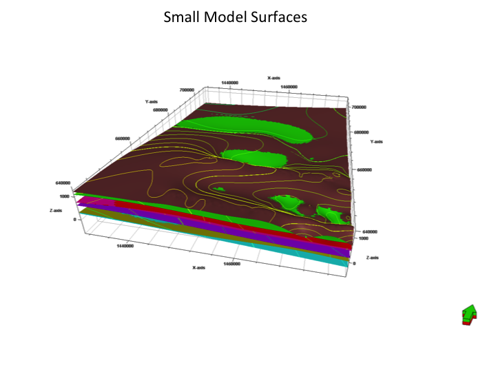
KD Small Extents
| Grid Team Member: | LANL Terry Miller |
| Data Version: | Prelim Kevin Dome (KD) |
| Data Source: | BigSky Carbon PETREL Model, Bob Will |
| Delivered To: | Phil Stauffer |
| Data Formats Confirmed: | Sep 6 2012 |
|
KD Full Region Extents
|
KD Small Extents
|
Data formats confirmed with Bob Will. Waiting for project description and model design.
Sep 6 2012
Data formats confirmed with Bob Will, new surfaces created with better interactions between the surfaces creating each layer (fewer intersections). Por and Perm properties have been recalculated. There will be new seismic data in another month or so. Start with the version we have. Note new figures showing the full Kevin Dome area, about 120 well tops. LANL will use mesh extents similar to the rectangle of the Small Model represented in prelim surfaces.
Bob will send new surfaces and properties to LANL to include:


1) Structural Surfaces exported from Petrel in Earthvision format.
   - Bob will try exporting with Z upward, otherwise we will multiply by -1.
   - Preferred file name convention;
     Earthvision scattered data format ending in ".dat" (So Earthvision can read).
     Surface names starting with 000 or 001 and numbered upward to top surface.
     This ensures we have the correct order and makes it easier using scripts.
   - Data summary and/or images of each surface elevation and layer isochores

2) Property data in GSLIB format including x,y,z,I,j,k, poro, perm for
   each cell of the Petrel/Eclipse grid.
   This is essentially a point data file with poro and perm value at each point.
   - The file size can be reduced by omitting the i,j,k fields.
   - Appending ".dat" allows Earthvision to import and display this data.
   - Data density based on data resolution.
   - Data summary and/or images of poro and perm for each layer
Surfaces are exported from Eclipse/ PETREL into Earthvision (EV) ascii format files. These files are viewed directly with EV and imported into LaGriT for use in Meshing and Model Setup.
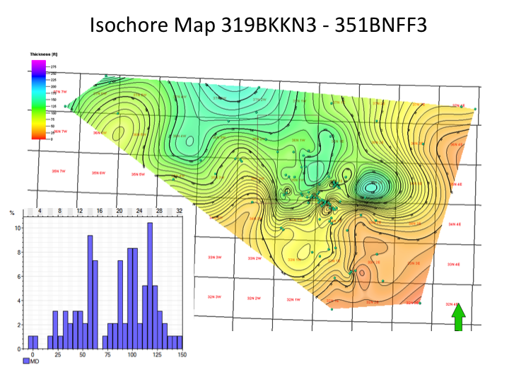
Summary Elevation and Isochore Images of each Layer (surface pairs)
LaGriT and PETREL Layers
Properties Poro and Perm from KD_Small_070712.GSLIB
GSLIB Property Images
Big Sky Carbon Sequestration Partnership Metadata


Title:  ExportedGrids_20120807

Creator:  Bob Will, Schlumberger Carbon Services

Subject: Kevin Dome, subsurface, static geologic model, reservoir characterization, grid files


Description:  Sample data exported from the Kevin Dome Petrel Model distributed to Flow Modeling teams to test grid format requirements and workflow.

	KD_SMALL_070712_GRDECL.zip - A series of (ascii) model files for our smaller grid in eclipse format. This information is fully descriptive for an eclipse user

	KD_Small_070712_GSLIB.zip - An ascii file in GSLIB format including x,y,z,I,j,k, poro,perm for each cell of our smaller grid. This may need to be supplemented by grid surfaces (below) and some basic info about the grid is provided in the powerpoint 20120808_KD_Model_Exports_070712.pptx.

	Petrophysics.zip - Two ascii files for each well that has poro and perm. One file contains x,y,x,poro,perm for each log sample. The other contains the well path description (deviation) for each well. The first actually contains all of the information needed to register the poro-perm values in 3D space but the deviation data is needed if the user wants to actually associate the data with a particular well.

	Small_Model_Surfaces.zipx - these are the surfaces from the small model at 300x300 resolution in EarthVision format. The user needs to know that I selected the option to reverse the sign of Z on export to make it conformal with normal earthvision convention.

	Smoothed_Full_Model_Surface.zipx - ? These are Alan?s full model surfaces but I have resampled them to 500x500 to make them more manageable size. Also in EarthVision format.


Petrel Project: Kevin_Dome_petR_3-20-12.petR
Date Exported: August 7 2012
Projection Information: SPCS27_2501:NAD27 Montana State Planes, Northern Zone, US Foot.


Access Information:  	Contact Stacey Fairweather for more information about data access - sfairweather@montana.edu  406.994.5742
			Contact Bob Will, SCS, for more information about data parameters and formats - RWill@slb.com

Use Limitations:  This data is distributed to BSCSP partners only.  Do not redistribute.  Data sharing between partners must be completed through BSCSP.


Posted Date:  August 8, 2012
/scratch/fwo/stauffer/BigSky

drwxr-xr-x  7 stauffer pf      4096 Aug 16 11:00 ./
drwxr-xr-x 34 stauffer pf      4096 Aug  8 14:54 ../
-rw-r--r--  1 stauffer pf      2317 Aug 16 10:17 20120808_DataDelivery_README.txt
-rw-r--r--  1 stauffer pf    535712 Aug 16 10:17 20120808_KD_Model_Exports_070712.pptx
drwxr-xr-x  2 stauffer pf      4096 Aug 16 11:00 20120808_KD_SMALL_070712_GRDECL/
drwxr-xr-x  2 stauffer pf      4096 Aug 16 09:55 20120808_Smoothed_Full_Model_Surface/
-rwxr-xr-x  1 stauffer pf 183289694 Aug  7 08:24 KD_Small_070712.GSLIB*
drwxr-xr-x  2 stauffer pf      4096 Aug 16 11:00 Original_Zips/
drwxr-xr-x  2 stauffer pf      8192 Aug 16 10:59 Petrophysics/
drwxr-xr-x  2 stauffer pf      4096 Aug 16 09:57 Small_Model_Surfaces/
/scratch/fwo/tam/BigSky/data_20120808
-rw-r--r-- 1 tam pf   2317 Aug 22 10:52 20120808_DataDelivery_README.txt
-rw-r--r-- 1 tam pf 541189 Aug 22 10:51 20120808_KD_Model_Exports_070712.pptx
-rw-r--r-- 1 tam pf 798497 Aug 24 07:38 Small_Surface_Exports.pptx
drwxr-xr-x 3 tam pf   8192 Aug 24 07:53 Small_Model_Surfaces/
drwxr-xr-x 2 tam pf      4096 Aug 27 14:38 Small_Surface_Isopachs/
drwxr-x--x 2 tam sftus   4096 Aug 27 15:11 Small_Model_GRDECL/
drwxr-x--x 3 tam sftus   4096 Aug 28 14:02 Small_Model_Prop/
-rw-r--r-- 1 tam pf      6178 Aug 27 15:08 README
| Carl Gable | gable -at- lanl -dot- gov | 505-665-3533 |
| Terry Miller | tamiller -at- lanl -dot- gov | 505-667-8009 |