Mesh Information README.txt
Gallery of Selected Images images/gallery_txt.html
Gallery of Mesh Issues: Ximages/gallery_txt.html
Gallery of All Images: images/gallery.html
Vers02 Mesh (on hold): images_workv02/gallery.html
|
Mesh Information README.txt Gallery of Selected Images images/gallery_txt.html Gallery of Mesh Issues: Ximages/gallery_txt.html Gallery of All Images: images/gallery.html Vers02 Mesh (on hold): images_workv02/gallery.html |
|
| Mesh Type: | 3D Unstructured Tetrahedral |
| Number of Nodes: | 452,618 |
| Number of Elements: | 2,582,936 |
| Features: | Regional Watertable, Tb4 (Basalt), and 83 wells with top and bottom screens |
| Data Source: | Watertable Surface from Weston EV draft WC09e May 25 2011 |
| Data Source: | Bottom Cerros del Rio (Tb4) from Weston EV draft WC09e May 25 2011 |
| Data Source: | 83 Wells and their screens from MYSQL extracted Jul 12 2011 |
| XYZ min max length: | (490000.00 510800.00 20800.00) (526697.87 543000.00 16302.13) (1100.00 2227.64 1127.64) meters |
| XYZ min max length: | (1607611.55 1675853.02 68241.47) (1728011.38 1781496.06 53484.68) (3608.92 7308.53 3699.60) feet |
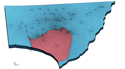
This mesh was built with LaGriT strategies that capture the resolution at 83 wells and the basalt and watertable interfaces, but also keep the total number of nodes below 500,000. The result captures resolution in important areas along the basalt and well locations - but only coarsely captures features such as the thin basalt arm on the west. This mesh is considered a first draft and new strategies can be used to improve the resolution and the mesh quality.
Mesh issues to address in next versions:
Using old version water table surface wt_surface_ev_WC09.inp
update to Aug 12 2011 From directory /scratch/er/monty/lanl/water table/maps/2011-02
cp wl*feb*811*ascii.grd /scratch/er/tam/er_monitoring_2011/watertables/wl_2011_feb_s_tw_20
110811.grd

Fix extreme elevation at intersectin of polygon and TB4 surface that creates a false spike
and bad ccoefs at elements at that edge. This is caused by TB4 "cliffs" where values past
TB4 boundary are very high or very low to represent the null data for the material.
The TB4 surface and water table surface should be clean and be coincident in the null area.

Negative coupling ccoefs along steeper west slope of water table surface (410 m edges).
- Reduce edge length of triangles to 230 - 300 meters to avoid problems in slope area (10
meter from next layer)
- Consider adding a layer of nodes above the water table

Negative coupling ccoefs at some wells along steep slope because the well object
is horizontal and does not form good connections where slopes are steep.
Use stack method to add layers to keep well columns (do not use offset)

Negative coupling ccoefs along TB4/water table interface caused by wedge shapes in pinchout.
   - Form a 10 meter high pinchout, blunt edge to TB4.
   - push TB4 zic down to 10m buffer layer ( wtr - 10 )
   - color tets by coarse hex and polygon fence

Fix well x,y locations that differ from mysql data
- R-53 has 2 different x,y locations 7 meters apart
- R-41 and possible others suffer from smoothing that should not have happened.
  8 and 24 m radial well pts should have true radial distance
- Need automatic way to deal with well objects that overlap such that one
  well will "win" over the previous and remove points that are too close to winning well
- Need automatic or script to buffer vertical well screens
  and perhaps add 1 meter vertical resolution to pumping well objects

What to do with well points that exist very close but not the same as mesh point.
- Remove mesh well wheel, add real well wheel? Or remove real well wheel, keep mesh wheel?
- What is "too close"? 1 meter? 8 meters?

Buffer the Tb4 polygon and remove interface points.
- need to create buffer polygons + - about 5 meters
- should have strategy or code to coarsen any given polygon to some edge length h
FEHMN Modeling files:
 /scratch/er/tam/er_monitoring_2011/fehm_2mat_3D_v01_wells/

Mesh Geometry and Connectivity (AVS ascii format)
 -rw-r--r-- 1 tam pf 395M Jul 29 13:55 tet_fehm.inp

Mesh Geometry and Connectivity (FEHM ascii format)
 -rw-r--r-- 1 tam pf 132M Jul 29 13:53 tet.fehmn

Sparse Matrix Voronoi Coefficients (FEHM ascii format)
 -rw-r--r-- 1 tam pf 130M Jul 29 13:56 tet_zero.stor

FEHM zone files
 -rw-r--r-- 1 tam pf 4.8M Jul 29 13:53 tet_material.zone
 -rw-r--r-- 1 tam pf 574K Jul 29 13:53 tet_multi_mat.zone
 -rw-r--r-- 1 tam pf 188K Jul 28 08:32 outside_top.zone_material.zone
 -rw-r--r-- 1 tam pf 188K Jul 28 08:32 outside_bottom.zone_material.zone
 -rw-r--r-- 1 tam pf  37K Jul 28 08:32 outside_east.zone_material.zone
 -rw-r--r-- 1 tam pf  30K Jul 28 08:32 outside_north.zone_material.zone
 -rw-r--r-- 1 tam pf  24K Jul 28 08:32 outside_south.zone_material.zone
 -rw-r--r-- 1 tam pf  12K Jul 28 08:32 outside_west.zone_material.zone

Zones for each node as top screen and bottom screen
-rw-r--r--  1 tam  pf   7665 Aug  8 13:48 bot_nodes_single.zone
-rw-r--r--  1 tam  pf   6750 Aug  8 13:48 top_nodes_single.zone

Zones for all nodes in each screen interval between top and bottom
-rw-r--r--  1 tam  pf  11144 Aug  8 13:48 well_node_intervals.zone


Mesh Screen Information
  -rw-r--r-- 1 tam pf 4.5K Jul 29 13:29 tops_mat_elev_node.dat
  -rw-r--r-- 1 tam pf 5.5K Jul 29 13:29 bots_mat_elev_node.dat
  -rw-r--r-- 1 tam pf  11K Jul 29 13:39 tops_vorvol_coords.dat
  -rw-r--r-- 1 tam pf  13K Jul 29 13:41 bots_vorvol_coords.dat

Input Screen Data
 -rw-r--r-- 1 tam pf  27K Jul 28 14:17 well_screens_bot.dat
 -rw-r--r-- 1 tam pf  22K Jul 28 14:17 well_screens_top.dat


Well data:
 /scratch/er/tam/er_well_data/

Earthvision Surface data:
 /scratch/er/lanl_ev_models/weston_surfs_2011/

Mesh work directory:
 /scratch/er/tam/er_monitoring_2011/grid_2mat_v01/
| Carl Gable | gable -at- lanl -dot- gov | 505-665-3533 |
| Terry Miller | tamiller -at- lanl -dot- gov | 505-667-8009 |