Full Mesh with Top at ground surface (2x)
Mesh Fit to Watertable (2x)
| Grid Team Member: | Terry Miller |
| Grid Name: | Mesh A 100x100x25 m for Amanzi |
| Data Source: | Earthvision HFM_PM_20140305 |
| Delivered To: | Ed Kwicklis and Lu Zhiming |
| Versions Used | Description and Size | Date |
| wtrfit |
Stretch Z to Fit Watertable (smooth top) 7,055,100 nodes 6,930,000 hex cells |
Feb 2015 |
| wtrfit walkabout 2 |
wtrfit for Amanzi->Walkabout New hextotet method 7,055,100 nodes 34,650,000 tet cells |
Jul 2018 |
| wtrfit walkabout 1 |
wtrfit for Amanzi->Walkabout Old connect method 7,178,902 nodes 46,865,773 tet cells |
May 2017 |
| wtr |
Mesh Truncated by Watertable (stair-step top) 6,609,041 nodes 6,485,453 hex cells |
Feb 2015 |
| full |
Mesh Truncated at Ground 7,910,556 nodes 7,754,821 hex cells |
Feb 2015 |
This Mesh was created for Test Bed Modeling is used to demonstrate EM HP computing capability for flow and transport in a geologically complex environment.
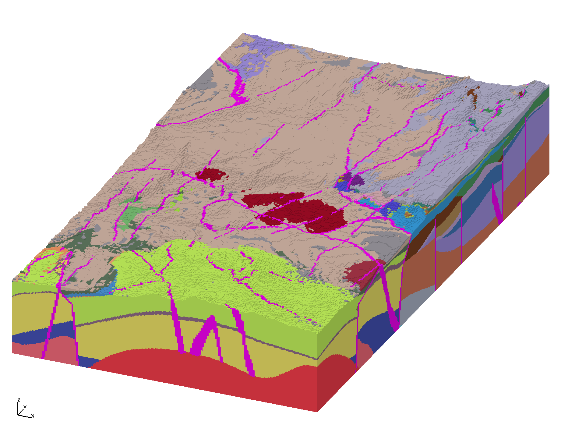
This is a large domain AMANZI model with 7M cells for Pahute Mesa transport corridor (Area 20, Bench and NW Caldera) using high-fidelity Earthvision model with 76 HSU's and 82 faults.
Particle tracking is run on the AMANZI->Walkabout tet mesh.
The domain is centered near ER-20-11 at 545777.5, 4116548.9 with
a bottom at -1000 Meters and a top at ground surface and at watertable surface.
Horizontal spacing is 100 m and vertical spacing is 25m except in the conforming watertable version in which the elevations are stretched proportionally to fit the watertable surface.
This Earthvision Model updates an earlier HFM conceptualized distribution of lava flow aquifers and fault surfaces within the Calico Hills Hydrostratigraphic Unit of the Pahute Mesa Phase I with Pahute Mesa Phase II Hydrostratigraphic Framework Model.
|
Full Mesh with Top at ground surface (2x)
|
Mesh Fit to Watertable (2x)
|
|
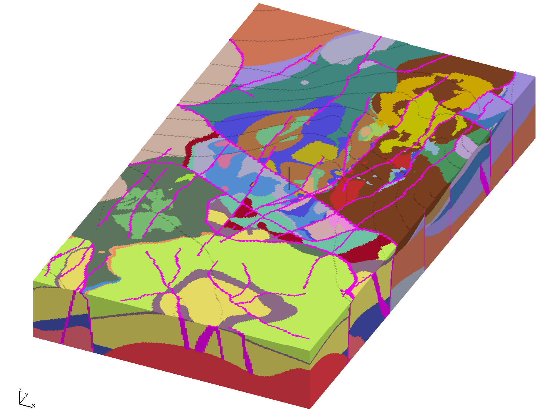
Mesh Fit to watertable with HSU labels 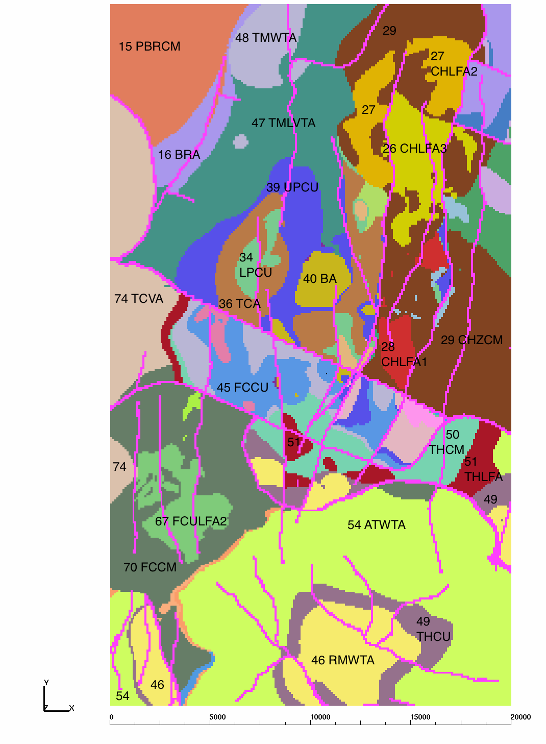
|
Mesh Faults with Fault labels 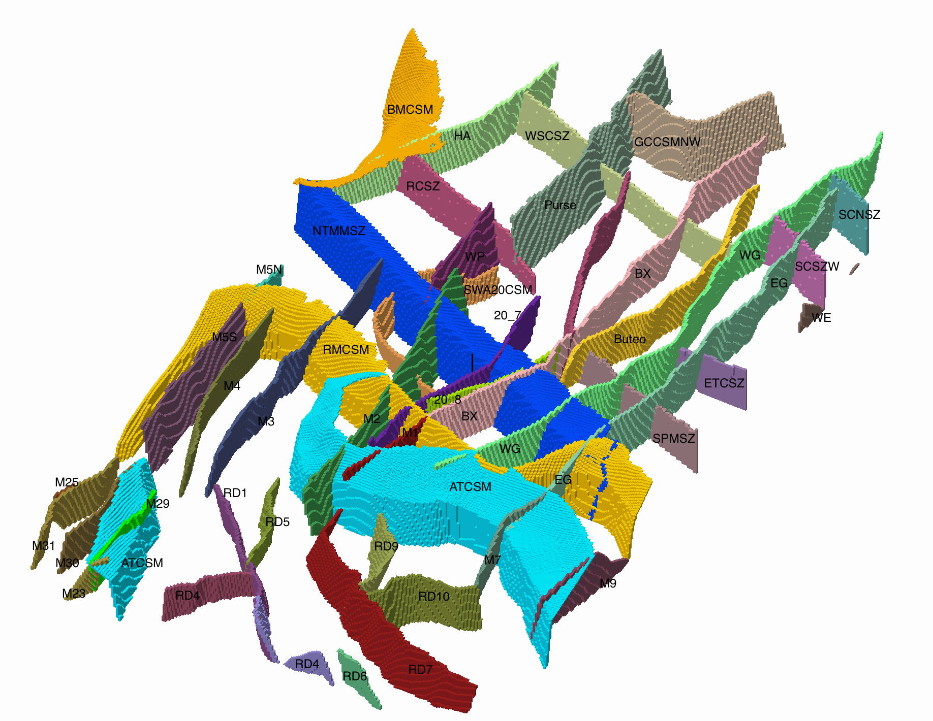
|
All Mesh Images 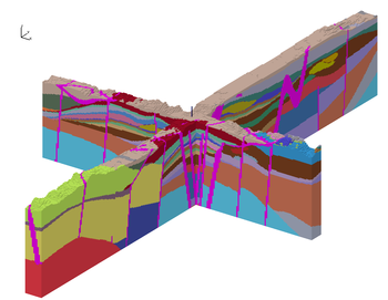
|
Model Fit Watertable 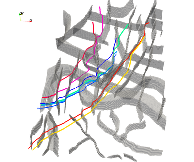
|
Earthvision Images of Domain 
|
These uniform grids have spacing of 100x100x25 meters.
Note the mesh fit to watertable has variable spacing near 25m and
conforming to the watertable surface. In this instance the xy spacing
is regular, but vertical spacing is stretched to meet watertable.
Mesh Materials include 51 EV HFM zones (1-74) and 44 faults (101-181)
Full Mesh extents:
 ATTRIBUTE       MIN               MAX         DIFFERENCE
 xic     5.350000000E+05     5.550000000E+05   2.000000000E+04
 yic     4.100000000E+06     4.135000000E+06   3.500000000E+04
 zic    -1.000000000E+03     2.200000000E+03   3.200000000E+03

Mesh top directory: /scratch/nts/tam/pahute_mesa/mesh_ER20_uniform/meshA_100_100_25
This is the mesh used for the Test Bed Modeling.
Hex Mesh Fit to watertable surface (smooth top):
  number of dimension: 3
  number of nodes: 7055100
  number of elements: 6930000
  number of element blocks: 95
  number of side sets: 6
  Elevation -1000 to 1468.45 meters
  -rw-r--r-- 1 tamiller sft 448547356 Feb 20 10:20 Amanzi_fit_watertable/hex_flts_wtrfit.exo
  README file Fit to watertable

  Paraview Images and Movie work are in
  /scratch/nts/tam/pahute_mesa/mesh_ER20_uniform/meshA_100_100_25/Amanzi_fit_watertable/VIS
Hex Mesh truncated by watertable surface (stair-stepped):
  number of dimension:               3
  number of nodes:             6609041
  number of elements:          6485453
  number of element blocks:         95
  number of side sets:              10
  Elevation -1000 to 1475 meters
  -rw-r--r-- 1 tamiller sft 420036380 Feb 18 12:57 Amanzi_trunc_watertable/hex_flts_wtr.exo
  README file truncated by watertable
Full Hex Mesh with Top at ground surface:
  number of dimension: 3
  number of nodes: 7910556
  number of elements: 7754821
  number of element blocks: 99
  number of side sets: 10
  Elevation -1000 to 2200 meters
  -rw-r--r-- 1 tamiller sft 502562728 Jan 29 16:06 Amanzi/hex_w_flts.exo
  README file for Full Mesh
Hex to Tet Mesh fit to Watertable Amanzi->Walkabout Method using hextotet 5 :
  number of nodes: 7055100
  number of elements: 34650000
  Amanzi_fit_watertable/walkabout_hextotet5
  README file for Walkabout Mesh 2
This version particle tracks have issues along boundaries due to meshing.
Hex to Tet Mesh fit to Watertable Amanzi->Walkabout Method using connect :
  number of nodes: 7178902
  number of elements: 46865773
  Amanzi_fit_watertable/walkabout
  README file for Walkabout Mesh 1
HSU definitions and Earthvision Model sent by
Tim Vogt
Supporting Navarro-Intera, LLC contracted to the
U.S. Department of Energy, NNSA Nevada Field Office
702-295-2057 office
702-994-2489 cell
Tim.vogt@nv.doe.gov

March 05, 2014 2:25 PM Download location
https://ugta.nv.doe.gov/sites/EarthVision/VisualizationLibrary/20140305_for_LANL.tar

Local:
     Interpolation from .seq file
     /scratch/nts/ev_models/HFM_PM_20140305/
     Final fault surfaces are created and merged into file
     /scratch/nts/ev_models/HFM_PM_20140305/fault_polygons/merge_ER20_meshA.inp

Post-process of Fault polygons used to create fault surfaces:
Kevin Day
Navarro-Intera, LLC / GeoHydros, LLC
Kevin.Day@nv.doe.gov
day@geohydros.com
NSF: (702)-295-2699
GeoHydros: (775)-337-8803
Mobile: (775)-225-1008

Support and analysis of area fault and geology:
Drellack, Sigmund
National Security Technologies, LLC
Contractor to the United States Department of Energy
Mail Address
  Mail Stop NLV 082
  P.O. Box 98521
  Las Vegas, NV 89193-8521
Phone: 702-295-0170
FAX: 702-295-1313
E-mail: drellasl@nv.doe.gov
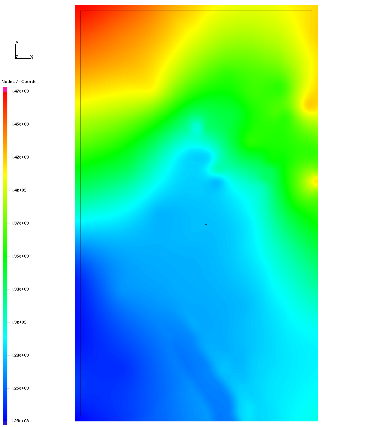
The top of the watertable mesh align with a potentiometric surface created by Ed Kwicklis
for the this PM model.
X = 500000 to 575000 m (UTM NAD 27)
Y = 4048000 to 4150000 m (UTM NAD 27)
Z = potentiometric surface in meters (1929 datum)

/scratch/nts/tam/pahute_mesa/mesh_ER20_uniform/watertable/PM-OV_Potentiometric_Surface_Rev3_2012_v3b.dat

| Carl Gable | gable -at- lanl -dot- gov | 505-665-3533 |
| Terry Miller | tamiller -at- lanl -dot- gov | 505-667-8009 |