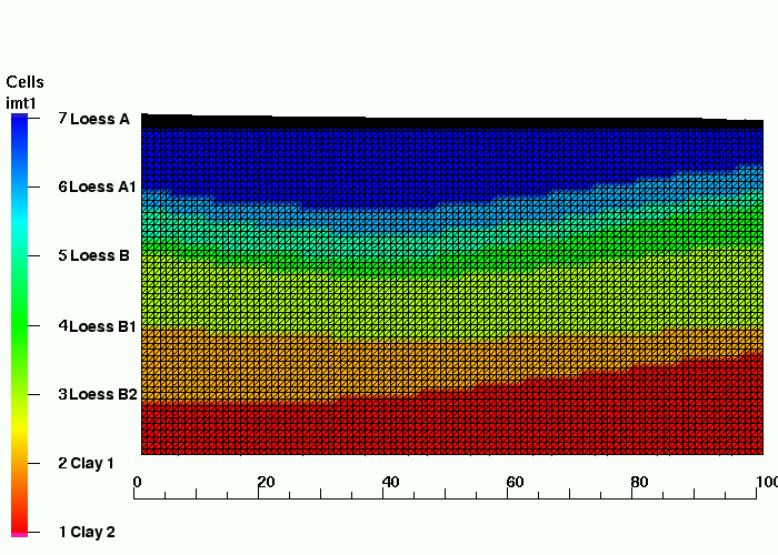
Final Computational Grid with 7 Materials

| Grid Team Member: | Terry A Miller |
| Grid Versions: | Version 04 |
| Data Source: | /scratch/stoshu2/Witk/Romanian/2001/Geology/Ver01 Romanian 2 |
| Delivered To: | Kay Birdsell and George Zyvoloski |
| Date Completed: | March 22 2002 |
A two dimensional grid is created with a cross-section perpendicular to the x-axis through the well FS2. This mesh extends north south and contains the real world coordinate data rather than a relative coordinate system. The grid incorporates stratigraphy from a 3D Hydrostratigraphic model(HFM) for material designations. This mesh differs from Version 3 in that the elevation is extended down to the water table at 10 meters. This captures both the Clay materials. Refinement to .1 meters has been added to the top two meters of the mesh. This is a structured grid, contains no negative coefficients, and is computable by FEHM.
|
Final Computational Grid with 7 Materials 
|
| Dimension: | 2D |
| Grid Element Type: | Triangle |
| Grid Software Used: | LaGrit, Gridder |
| Number of Nodes: | 6933 |
| Number of Elements: | 13518 |
The Grid Method successfully follows the design criteria.
/scratch/fourier2/tam/romanian_2002/Rom2001_2Dv4
-r--r-----   1 tam        938391 Mar 20 14:39 rom2001_2Dv4.fehmn
-r--r-----   1 tam       2294424 Mar 20 14:39 rom2001_2Dv4.stor
-r--r-----   1 tam          4806 Mar 20 14:39 rom2001_2Dv4_interface.zone
-r--r-----   1 tam         76404 Mar 20 14:39 rom2001_2Dv4_material.zone
-r--r-----   1 tam         40009 Mar 20 14:39 rom2001_2Dv4_multi_mat.zone
-r--r-----   1 tam         23608 Mar 20 14:39 rom2001_2Dv4_outside.area
-r--r-----   1 tam          2158 Mar 20 14:39 rom2001_2Dv4_outside.zone
/scratch/stoshu2/Witk/Romanian/2001/Geology/Ver01/Surfaces
-rw-r-----   1 witk       616669 Oct 19  2000 romanian_3D.inp
-rw-r-----   1 witk        54400 Oct 18  2000 romanian_surf001.inp
-rw-r-----   1 witk        53962 Oct 18  2000 romanian_surf002.inp
-rw-r-----   1 witk        53969 Oct 18  2000 romanian_surf003.inp
-rw-r-----   1 witk        53972 Oct 18  2000 romanian_surf004.inp
-rw-r-----   1 witk        53972 Oct 18  2000 romanian_surf005.inp
-rw-r-----   1 witk        53972 Oct 18  2000 romanian_surf006.inp
-rw-r-----   1 witk        53972 Oct 18  2000 romanian_surf007.inp
-rw-r-----   1 witk        53972 Oct 18  2000 romanian_surf008.inp
| Carl Gable | gable@lanl.gov | 505-665-3533 |
| Terry A Miller | tam@vega.lanl.gov | 505-667-8009 |