Grid Project: WY STATE CO2 2009
| Grid Team Member: |
Terry Miller |
| Grid Versions: |
coarse stacked |
| Data Source: |
EV Fault Model by Zunsheng (John) Jiao |
| Delivered To: |
Phil Stauffer and John |
| Date Completed: |
October 7 2009 |
Mesh Version 01
Coarse Stacked Mesh, no buffer layers
512 and 256 meter horizontal spacing
Description and Images
|
|
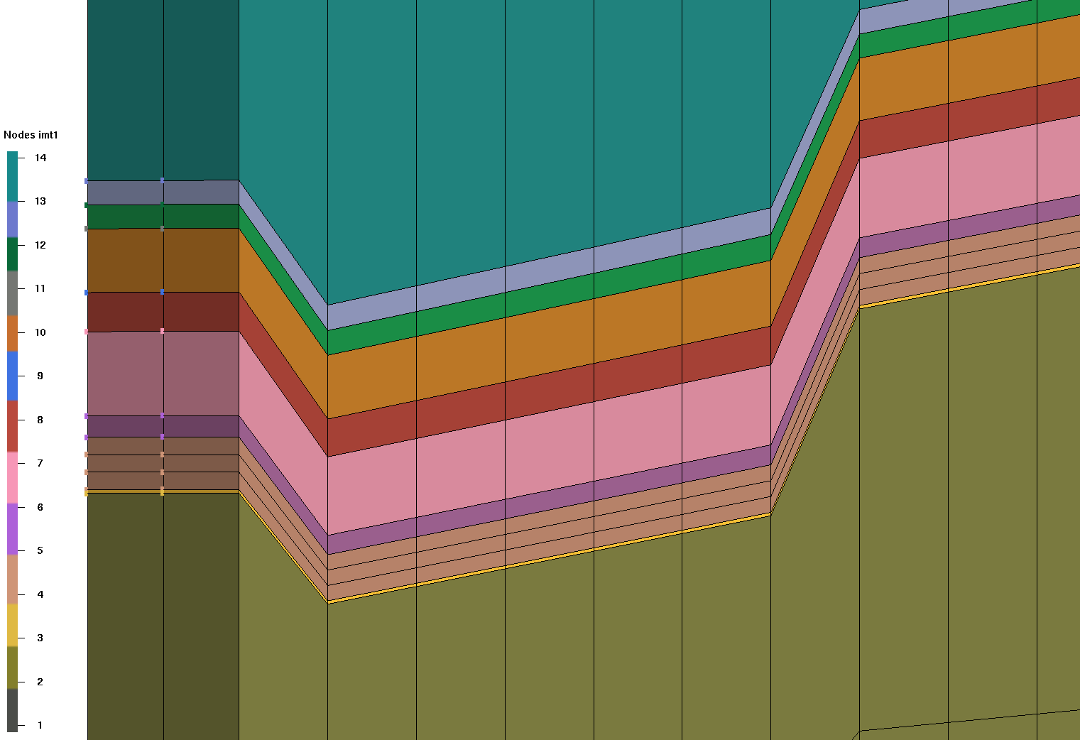
Mesh Materials from Earthvision Model
Material Kbl   14 Blair
Material Kba   13 Baxter
Material Kf    12 Frontier
Material Kmr   11 Mowry Shale
Material Kmd   10 Dakota
Material Jm     9 Morrison
Material Je     8 Entrada
Material Jn     7 Nugget
Material Tc     6 Chugwater
Material Pp     5 Phosphoria
Material Pw     4 Weber
Material PMa    3 Amsden
Material Mm     2 Madison
Material Mmb    1 Bedrock
|
Purpose of Project
Build a new model that is large enough to include nearest major faults and with enough resolution to represent 9 injections wells and their area of influence. The outside boundaries are aproximately 70Km x 70 Km and the Injection site is about 3000 meter square.
The first mesh is built with coarse vertical and horizontal layering for easy setup and runs with FEHM. The solutions on this mesh will be used to design a higher resolution mesh.
(2009 letter and description)
A CD contained all files in the RSU 3D modeling folder is sent
to by overnight mail. You should receive it tomorrow or Friday. The
tracking number is EB914441064US. I used ev 7.5.3 to build the model.
If you have any question please let me know.
One task of the RSU geological CO2 sequestration project is to
evaluate the CO2 injection feasibility and storage capacity of the Weber
Sandstone and Madison Limestone in the Rock Springs Uplift, Wyoming.
The Rock Springs Uplift is a large (50 miles by 35 miles),
doubly-plunging anticline characterized by more than 10,000 feet of
closed structural relief. The potential CO2 storage reservoirs are the
Pennsylvanian Weber Sandstone and the Mississippian Madison Limestone.
The Weber Sandstone is approximately 700 feet thick, and the Madison
Limestone is approximately 250 feet thick. Both units have substantial
porosity (storage) and permeability (deliverability). Neither the Weber
nor the Madison is exposed on the Rock Springs Uplift; the nearest
surface outcrops of these units are 50 to 100 miles from the margins of
the structure. Consequently, these two formations are far removed from
any meteoric water recharge and have retained their original
marine/evaporite character (saline). At the crest of the Uplift, the
Weber lies 6,200 feet below ground and the Madison lies 7,500 feet below
ground. On the flanks of the structure, these units lie 15,000 feet or
more below ground. Within the Rock Springs Uplift, both the Weber
Sandstone and the Madison Limestone have temperature and pressure
attributes that make them ideally suited to accept huge amounts of
injected CO2.
Five thousand feet of low-permeability Cretaceous shales overlie
the Weber and the Madison, and make an ideal seal for the CO2 storage
reservoirs. The composition of produced gas from the Weber and Madison
units - sour and up to 80% CO2 - demonstrates the sealing capacity of
these shales. In strong contrast, gas produced from Cretaceous
sandstones above the shales is sweet and typically less than 1% CO2.
This significant difference in fluid chemistry between the Paleozoic and
Cretaceous stratigraphic units negates the potential for vertical fluid
connectivity on the Rock Springs Uplift.
The available data show that fluid salinity in the Weber
Sandstone generally exceeds 35,000 ppm, and fluid salinity in the
Madison Limestone ranges from 50,000 to 80,000 ppm. Both the Weber
Sandstone and the Madison Limestone within the Rock Springs Uplift are
considered saline aquifers. In the Rock Springs Uplift, salinities of
the two aquifers in question far exceed the acceptable level: these
aquifers could not be used for drinking water.
Significant Cretaceous oil and gas production occurs on the
Uplift, while significant Paleozoic oil and gas production occurs on
Uplift margins. On the Uplift, 75 wells have penetrated the Paleozoic:
30 of these are plugged and abandoned; 14 are shut in or abandoned but
not plugged; and 31 are active. Therefore, there are 45 wells on the
Uplift that could be used as injecting or monitoring wells for
geological CO2 sequestration activities.
John
Zunsheng (John) Jiao
Senior Geologist/Geological Project Analyst
Wyoming State Geological Survey
P. O. Box 1347
Laramie, Wyoming 82073
Phone: (307) 766-2286 ext. 225
Fax: (307) 766-2605
http://www.wsgs.uwyo.edu
Project Archive Location
FEHMN files for enter_grid_name:
/scratch/fwo/tam/wy_2009/grid_work/fehm_coarse
-rw-r--r--  1 tam pf 157197456 Oct  7 08:22 tet_final.gmv
-rw-r--r--  1 tam pf 362667134 Oct  7 08:23 tet_final.inp
-rw-r--r--  1 tam pf 181531426 Oct  7 08:23 tet.fehmn
-rw-r--r--  1 tam pf   6582347 Oct  7 08:23 tet_material.zone
-rw-r--r--  1 tam pf   3656405 Oct  7 08:23 tet_interface.zone
-rw-r--r--  1 tam pf  50109510 Oct  7 08:43 tet_multi_mat.zone
-rw-r--r--  1 tam pf    950894 Oct  7 08:43 tet_outside.zone
-rw-r--r--  1 tam pf   5488417 Oct  7 08:43 tet_outside.area
-rw-r--r--  1 tam pf 203691921 Oct  7 08:44 tet_asciic.stor
Data files:
/scratch/fwo/wyo_ev_models/RSU_AUG09_fault/surfaces_coarse/
Work Directory:
/scratch/fwo/tam/wy_2009/grid_work
drwxr-xr-x  4 tam pf  4096 Sep  9 10:28 refine_quad/
drwxr-xr-x  3 tam pf  8192 Oct  6 14:22 stack_coarse/
Grid Team Contacts
| Carl Gable |
gable -at- lanl -dot- gov |
505-665-3533 |
| Terry Miller |
tamiller -at- lanl -dot- gov |
505-667-8009 |