(Version 02)
(Scoping Mesh)
| Grid Team Member: | Terry Miller |
| Grid Version: | Version 02 Stacked Upscale Mesh |
| Data Source: | EV La Barge Model seis3d, por, and perm from John Jiao, WSGS |
| Delivered To: | Phil Stauffer |
| Date Completed: | 4/19/2011 |
| Grid Version: | Version 01 Brick Mesh |
| Data Source: | EV La Barge Model seis3d from John Jiao, WSGS |
| Delivered To: | Phil Stauffer |
| Date Completed: | 2/22/2011 |
|
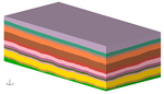
Stacked Mesh Images
|
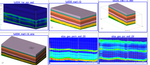
Stacked Upscale Images
|
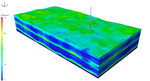
All Stack Images (Version 02)
|
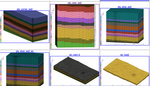
All Brick Images (Scoping Mesh)
|
|
Generate a mesh for the 3-D model (from La Barge 3-D seismic data) sent by John Jiao, WSGS
. The mesh will represent an injection well in the middle of the survey to evaluate how much CO2 could be
injected to Weber Sandstone and Madison Limestone.
The well location is at X 482800 ft and Y 476300 ft. The target interval Weber Sandstone
at the well location for CO2 injection ranges from -10600 to -11800 ft (elevation) or depth 11300 to 18500 ft in depth.
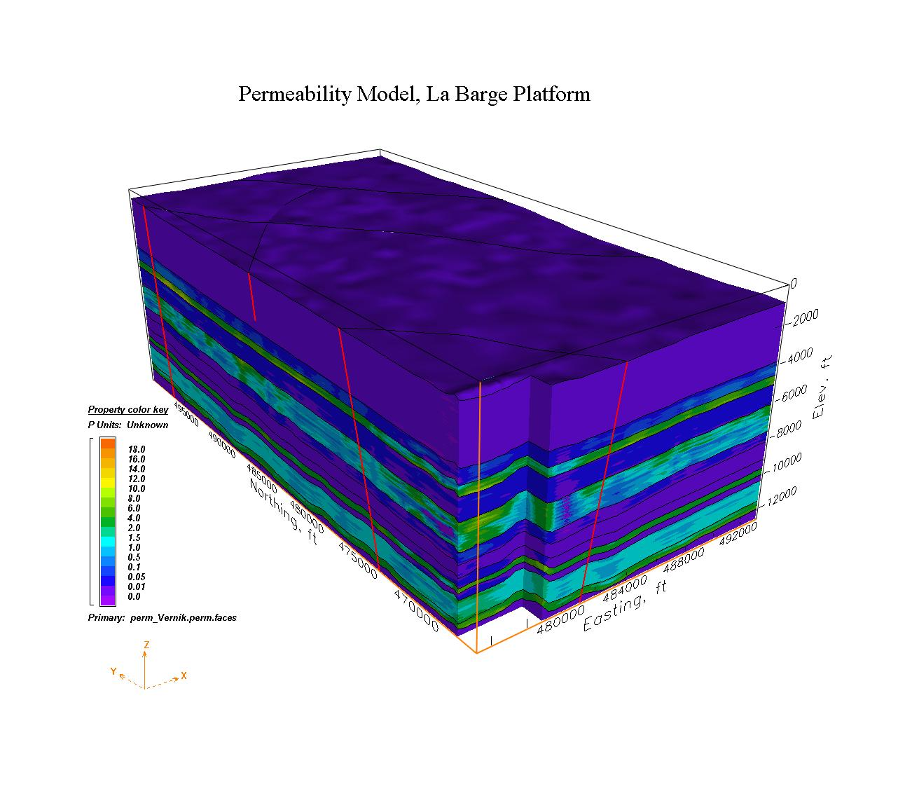
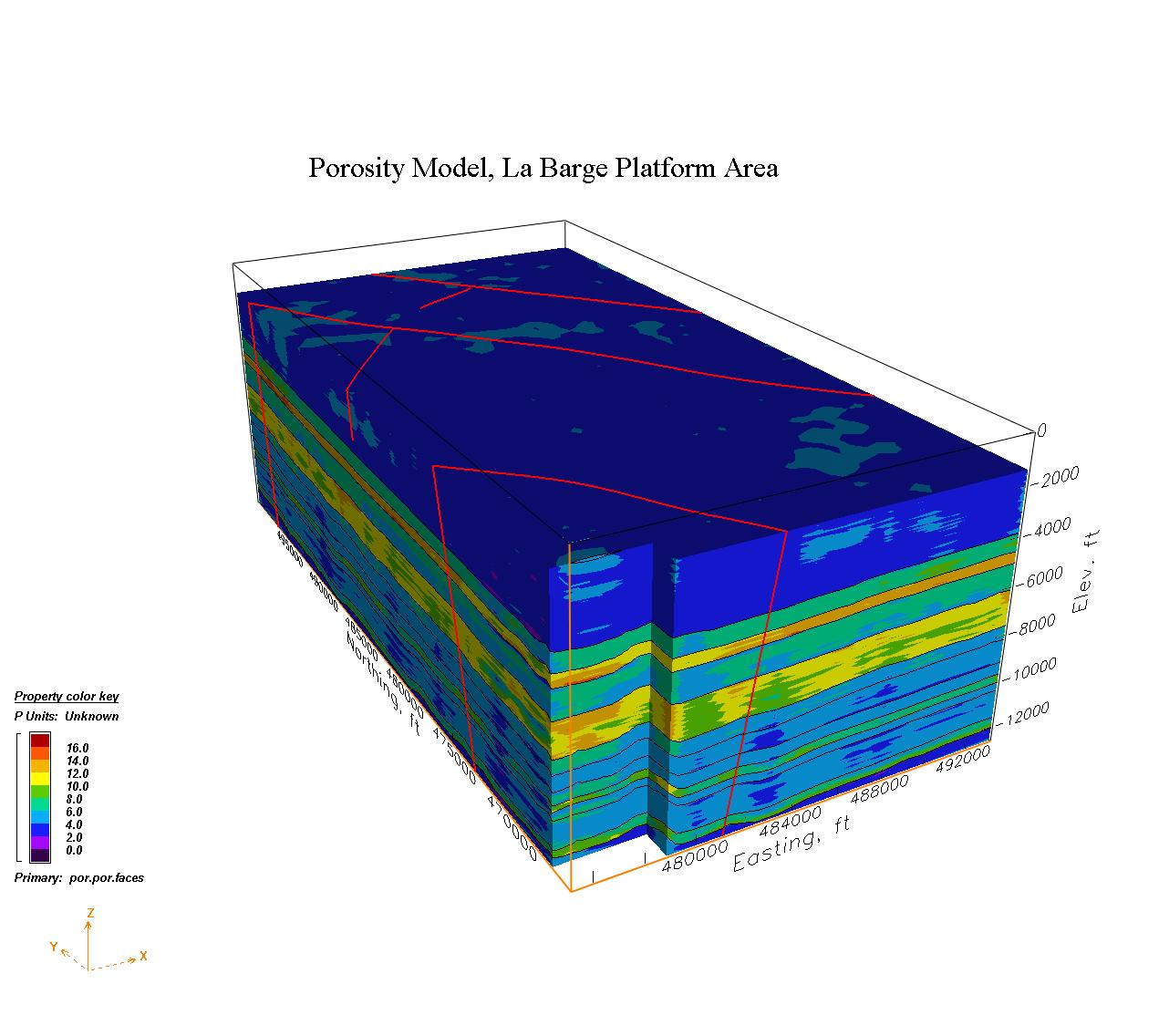
The Wyoming EV model consists of La Barge structural (seis3d), porosity (por), and permeability (perm_Verik) models.
Three faces files are included, seis3d.faces for structure, por.faces for porosity, and perm_Vernik.faces for permeability. For this model, only the perm and por values for the target intervals, above, and below are needed.
The porosity and permeability values are imported from sets of scattered point values into Earthvision and applied to each of the intervals. The points in each of the perm and por data sets are at locations scattered through each interval at spacings near 36 meter horizontal and 24 meters vertical depending on the thickness of the interval. The following are ranges of perm and por values in some of the EV input files.
EV INPUT DATA           MIN              MAX             DIFFERENCE         POINTS

Weberperm.pdat         1.543100000E-01  1.177211000E+01 1.161780000E+01     81472
Weberpor.pdat         -7.200000000E+00  1.410000000E+01 2.130000000E+01     81472

Amsdenperm.pdat        0.000000000E+00  6.481000000E-02 6.481000000E-02     80085
Amsdenpor.pdat         0.000000000E+00  7.500000000E+00 7.500000000E+00     80095

Madisonperm.pdat      -3.851100000E-01  3.111700000E+00 3.496810000E+00    274056
Madisonpor.pdat       -1.400000000E+00  7.500000000E+00 8.900000000E+00    274056

Bighornperm.pdat      -5.033200000E-01  9.079820000E+00 9.583140000E+00    102541
Bighornpor.pdat       -2.400000000E+00  1.170000000E+01 1.410000000E+01    102541

Gallatinperm.pdat      0.000000000E+00  1.212000000E-02 1.212000000E-02    131436
Gallatinpor.pdat      -1.600000000E+00  5.900000000E+00 7.500000000E+00    131509
         geometric = sink_val = exp((src_val(tot) + src_val(i)) / num_nodes)
         harmonic  = sink_val = num_nodes/(src_val(tot) + log(src_val(i)))

         where src_val(i to n) are all source nodes found within the Voronoi cell of the sink node.
         num_nodes are the total number of nodes found within the Voronoi cell.
The resulting min and max values for the mesh are:
Note, for upscale of porosity, values less than .01 were not used.
Note, for upscale of permability, values less than .001 were not used.

 TYPE     ZONE     MIN               MAX         DIFFERENCE            NODES

 geo_por  2       3.732371748E+00  9.894222475E+00 6.161850727E+00      6816
 geo_por  3       2.472149289E+00  5.697207347E+00 3.225058058E+00     17040
 geo_por  5       2.346875512E+00  9.759063542E+00 7.412188031E+00      6816

 har_por  2       3.714583828E+00  9.890699429E+00 6.176115600E+00      6816
 har_por  3       2.417342878E+00  5.673898700E+00 3.256555822E+00     17040
 har_por  5       2.165081923E+00  9.754890486E+00 7.589808564E+00      6816

 geo_perm 2       8.804651971E-01  5.895848167E+00 5.015382970E+00      6816
 geo_perm 3       6.311931812E-02  1.830595789E+00 1.767476471E+00     17040
 geo_perm 5       4.115482301E-02  4.944154737E+00 4.902999914E+00      6816

 har_perm 2       5.864018415E-02  5.888640795E+00 5.830000611E+00      6816
 har_perm 3       3.174241531E-03  1.802413618E+00 1.799239376E+00     17040
 har_perm 5       2.027330417E-03  4.937167320E+00 4.935139990E+00      6816
|
EV La Barge Model 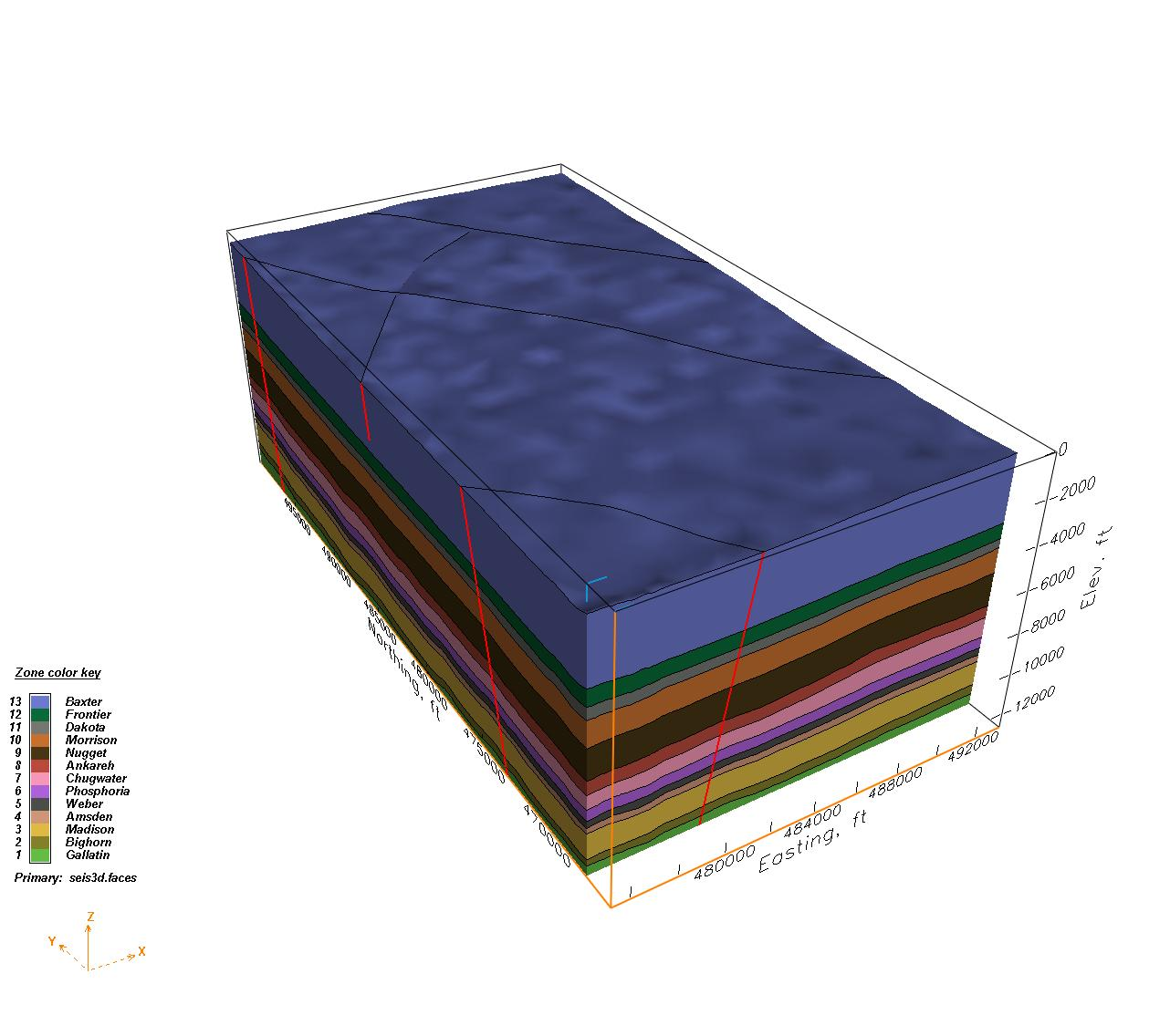
|
LaGriT Stacked Mesh 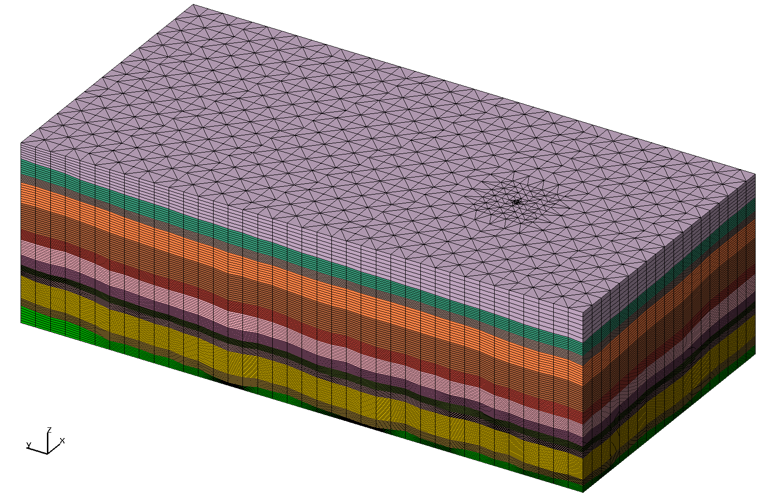
|
This Version 02 mesh uses the LaGriT stack method to create a mesh with variable vertical
resolution based on interval type and horizontal spacing based on an octree grid with embedded radial well.
It differs from Version 01 in that it gives up some horizontal in the area around the well vicinity to add resolution for the target intervals of Bighorn, Madison, and Weber. The horizontal distance from the well center to next horizontal node is still 32 meters.
number of nodes      =    98832
number of tetrahedra =   605075

Flat bottom at -3850. and flat top in Baxter at -800.
Note the EV model does not have a flat bottom or top.

 xic         1.448530000E+05  1.497170000E+05 4.864000000E+03     98832
 yic         1.426160000E+05  1.523440000E+05 9.728000000E+03     98832
 zic        -3.850000000E+03 -8.000000000E+02 3.050000000E+03     98832
Number of nodes per layer after interfaces have been removed:

  Baxter    13 has      5964 nodes and   7  layers  62m vertical spacing near well
  Frontier  12 has      5112 nodes and   6  layers  31m vertical spacing near well
  Dakota    11 has      5112 nodes and   6  layers  18m vertical spacing near well
  Morrison  10 has      6816 nodes and   8  layers  42m vertical spacing near well
  Nugget     9 has     10224 nodes and  12  layers  34m vertical spacing near well
  Ankareh    8 has      6816 nodes and   8  layers  21m vertical spacing near well
  Chugwater  7 has      7668 nodes and   9  layers  20m vertical spacing near well
  Phosphoria 6 has      7668 nodes and   9  layers  16m vertical spacing near well
  Weber      5 has      6816 nodes and   8  layers  12m vertical spacing near well
  Amsden     4 has      6816 nodes and   8  layers  13m vertical spacing near well
  Madison    3 has     17040 nodes and  20  layers  17m vertical spacing near well
  Bighorn    2 has      6816 nodes and   8  layers  16m vertical spacing near well
  Gallatin   1 has      5964 nodes and   7  layers  22m vertical spacing near well
Step 1) Create high res point sets with extracted perm and por
        This version has point spacing of 32m horizontal and vertical near 10 meters

Step 1.1) Extract 32m quad surfaces from EV interfaces using EV ev_label
        /scratch/fwo/wyo_ev_models/LaBarge1/lagrit_surfaces_32m

Step 1.2) Stack 32m quad surfaces into high res vertical distribution (10 meter target)
        foreach material zone point set: color by zone, color by perm, color by por
        use EV ev_label

Step 2) Create template with quad background and embedded well using LaGriT scripts
         /scratch/fwo/tam/wy_2011/grid_template
        Spacing is 256m, 128m in well region, 32 to 64m at well location.
        This template is vers02 and has least number of nodes possible with 852 nodes


Step 3) Create version 02 computational mesh
        /scratch/fwo/tam/wy_2011/grid_stack_vers02
        Stack surfaces with octree refinement and embedded radial well
        Spacing is 256m, 128m in well region, 32 to 64m at well location.
        Note: manually creating offset surfaces creates fully conforming interfaces
              the stack method will result in column oriented voronoi volumes

Step 3.1) Create material zone surfaces using LaGriT interpolate

Step 3.2) Stack into layers with target 10 meter vertical spacing at important zones (1-6)

Step 3.3) Remove interface points and connect
          grid_stack_vers02/connect_pyramid
          The high ascpect ratio causes connect/delaunay to pop connections into bad ccoefs
          Use the pyramid algorithm to connect with higher precision and 0 bad ccoefs

Step 4) upscale perm and por values on to the mesh using LaGriT and high res points from Step 1
        Find the geometric or harmonic average of source values found from the high res source nodes
        located on or inside the Voronoi volume of the associated mesh node.
        /scratch/fwo/tam/wy_2011/grid_pdata_vers02
        For perm and por calculate both the geometric and harmonic values

         geometric = sink_val = exp((src_val(tot) + src_val(i)) / num_nodes)
         harmonic  = sink_val = num_nodes/(src_val(tot) + log(src_val(i)))

         where src_val(i to n) are all source nodes found within the Voronoi cell of the sink node.
         num_nodes are the total number of nodes found within the Voronoi cell.

Step 5) write final fehm files and the perm and por attributes for the mesh
        /scratch/fwo/tam/wy_2011/fehm_grid_vers02
/scratch/fwo/wyo_ev_models/LaBarge1
  Geologic Material Zones: seis3d.seq
  Porosity Model: por.seq
  Permeability Model: perm_Vernik.seq
-rw-r--r--  1 tam  _update_sharing  31825201 Apr 14 16:39 tet.fehmn
-rw-r--r--  1 tam  _update_sharing  40042033 Apr 14 16:39 tet.stor

-rw-r--r--  1 tam  _update_sharing    169483 Apr 14 16:39 tet_outside.zone
-rw-r--r--  1 tam  _update_sharing    977959 Apr 14 16:39 tet_outside_vor.area

-rw-r--r--  1 tam  _update_sharing   1087413 Apr 14 16:39 tet_material.zone

-rw-r--r--  1 tam  _update_sharing      1306 Apr 14 16:39 tet_well_material.zone

-rw-r--r--  1 tam  _update_sharing    10282 Apr 14 16:41 well_points.dat
-rw-r--r--  1 tam  _update_sharing   7807786 Apr 14 16:43 tet_points.dat

por and perm values from mesh:

# lineno, geo_por, real har_por, real geo_perm, real har_perm, real node_num, integer
 1  0.361328778708E+01  0.342898998398E+01  0.140396843872E+01  0.314762414078E-01   36637
 2  0.667792173748E+01  0.662089824600E+01  0.249421853478E+01  0.119747208245E+00   36638
 3  0.572694935416E+01  0.567222332546E+01  0.957545348408E+00  0.267068050203E-01   36639

-rw-r--r-- 1 tam pf   566667 Apr 15 09:43 pvalue_mat01.dat
-rw-r--r-- 1 tam pf   647607 Apr 15 09:43 pvalue_mat02.dat
-rw-r--r-- 1 tam pf  1618887 Apr 15 09:43 pvalue_mat03.dat
-rw-r--r-- 1 tam pf   654423 Apr 15 09:44 pvalue_mat04.dat
-rw-r--r-- 1 tam pf   654423 Apr 15 09:44 pvalue_mat05.dat
-rw-r--r-- 1 tam pf   736215 Apr 15 09:44 pvalue_mat06.dat
-rw-r--r-- 1 tam pf   736215 Apr 15 09:45 pvalue_mat07.dat
-rw-r--r-- 1 tam pf   654423 Apr 15 09:45 pvalue_mat08.dat
|
Brick Mesh Zone Materials 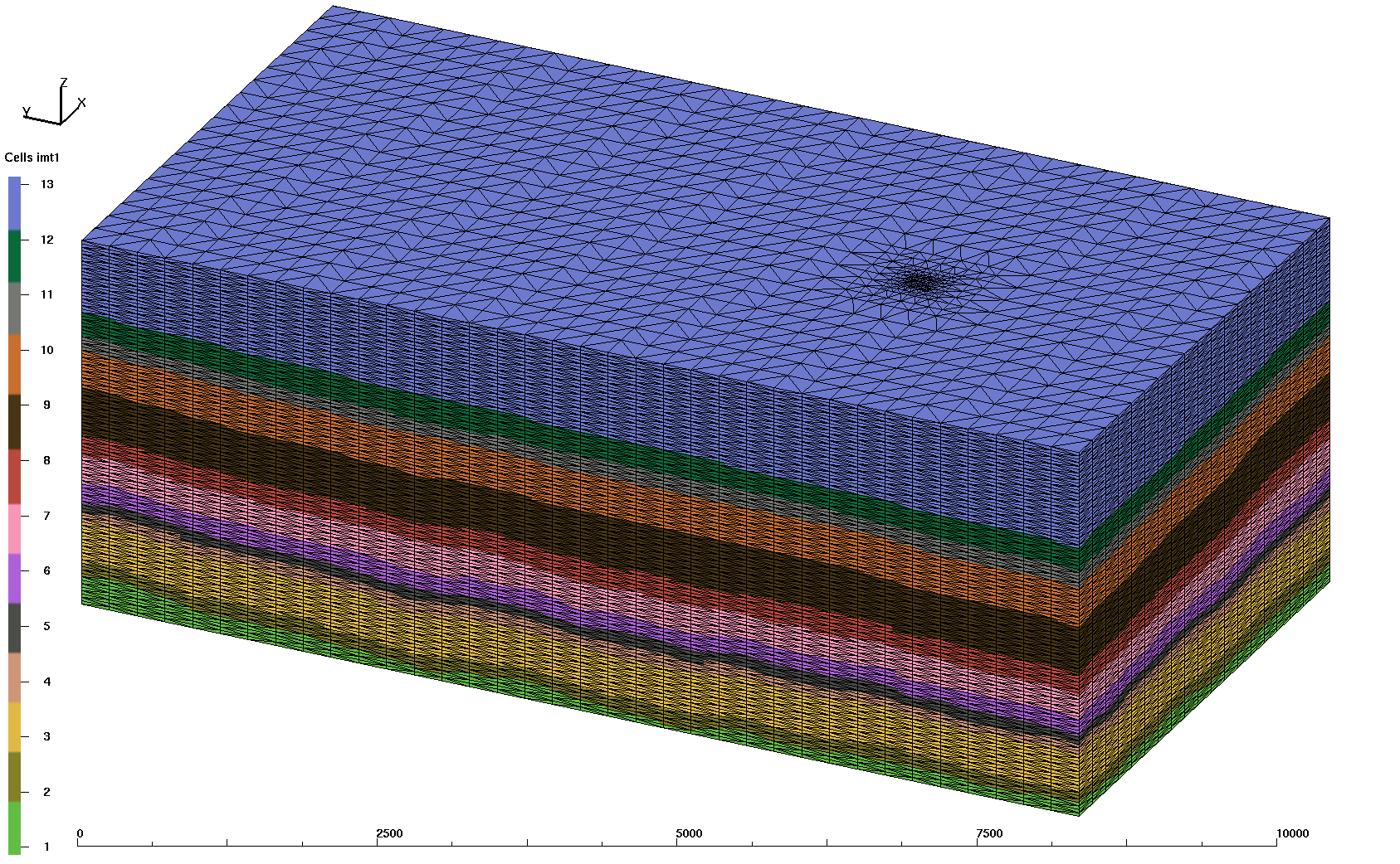
|
This version 01 scoping mesh has 32 meter vertical resolution and octree horizontal spacing from 32 meter near well to 256 meter away from the well. This version is too coarse for upscale methods. The Brick Mesh was created using LaGriT input files and Earthvision on the command line to query material zone values for the mesh point locations.
Project Pages for Version 01 Brick Mesh
/scratch/fwo/tam/wy_2011/grid_brick
-rw-r--r-- 1 tam pf 29076342 Feb 22 11:44 tet.fehmn
-rw-r--r-- 1 tam pf 18838609 Feb 22 11:45 tet.stor

-rw-r--r-- 1 tam pf  1069157 Feb 22 11:44 tet_material.zone
-rw-r--r-- 1 tam pf  1697350 Feb 22 11:44 tet_multi_mat.zone
-rw-r--r-- 1 tam pf   154411 Feb 22 11:44 tet_outside.zone
-rw-r--r-- 1 tam pf   890543 Feb 22 11:44 tet_outside_vor.area

-rw-r--r-- 1 tam pf  9521403 Feb 25 13:00 tet_node_attributes.dat

-rw-r--r-- 1 tam pf 36694069 Feb 22 11:44 tet_connect.inp
-rw-r--r-- 1 tam pf 22372448 Feb 22 11:44 tet_connect.gmv
-rw-r--r-- 1 tam pf 29102771 Feb 22 11:44 tet_grid.plt
| Carl Gable | gable -at- lanl -dot- gov | 505-665-3533 |
| Terry Miller | tamiller -at- lanl -dot- gov | 505-667-8009 |