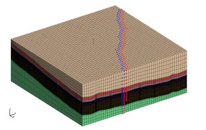
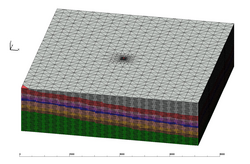
Hex Mesh with Fault Images
(Scoping Mesh)
Coarse Brick Mesh Images
(Preliminary Scoping Mesh)
| Grid Team Member: | Terry Miller |
| Grid Version: | Version High Res Stacked Perm/Por Mesh |
| Data Source: | EV JB3D Model jb3delev, por, and perm from John Jiao, WSGS |
| Delivered To: | Phil Stauffer |
| Date Completed: | 4/12/2012 |
| Grid Version: | Version Hex Mesh with Fault |
| Data Source: | EV JB3D Model jb3delev from John Jiao, WSGS |
| Delivered To: | Phil Stauffer |
| Date Completed: | 8/26/2012 |
| Grid Version: | Version Coarse Brick Mesh |
| Data Source: | EV JB3D Model jb3delev from John Jiao, WSGS |
| Delivered To: | Phil Stauffer |
| Date Completed: | 3/22/2012 |
|
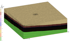
Refined Mesh with Well Images
|
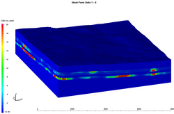
Refined Mesh with Perm Images
|
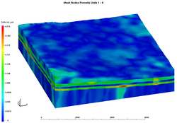
Refined Mesh with Poro Images
|
|
Hex Mesh with Fault Images (Scoping Mesh)
|
Coarse Brick Mesh Images (Preliminary Scoping Mesh)
|
|
Generate a mesh for the 3-D model (from EV jb3delev geology and data) sent by John Jiao, WSGS
. The mesh will represent an injection well in the middle of the survey to evaluate how much CO2 could be
injected to Weber Sandstone and Madison Limestone.
The high resolution units include Madison, Amsden, Weber, Phosphoria, and Dinwoody. The bottom unit, Darby, and the top combined units are thick units with the largest spacing. The mesh has a target of 6m vertical spacing in the high res units, with an upper limit of 300,000 total mesh nodes. The well is represented by a column of nodes with same vertical spacing as rest of mesh, and minimal horizontal refinement to keep the total number of mesh nodes below the limit.
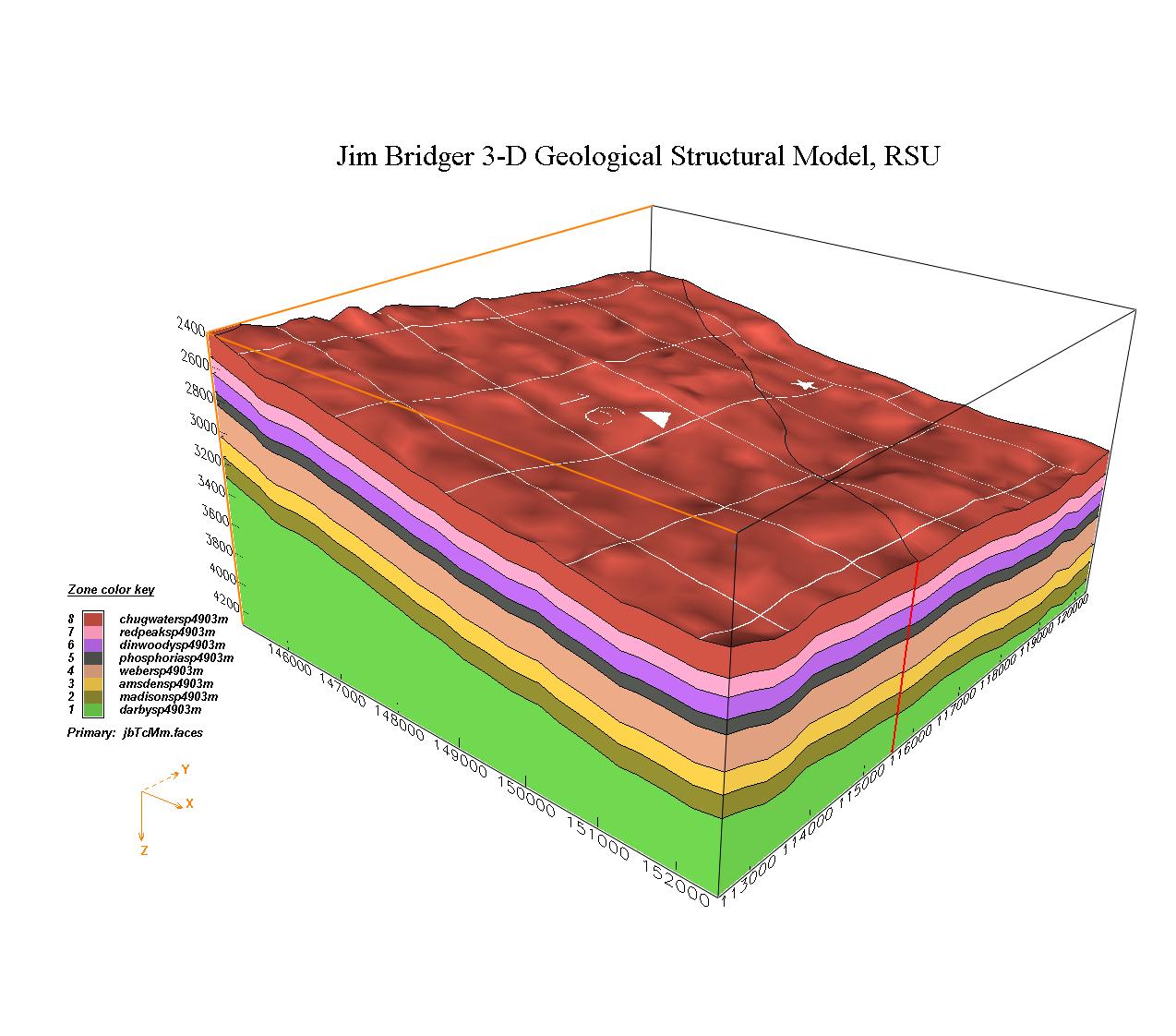
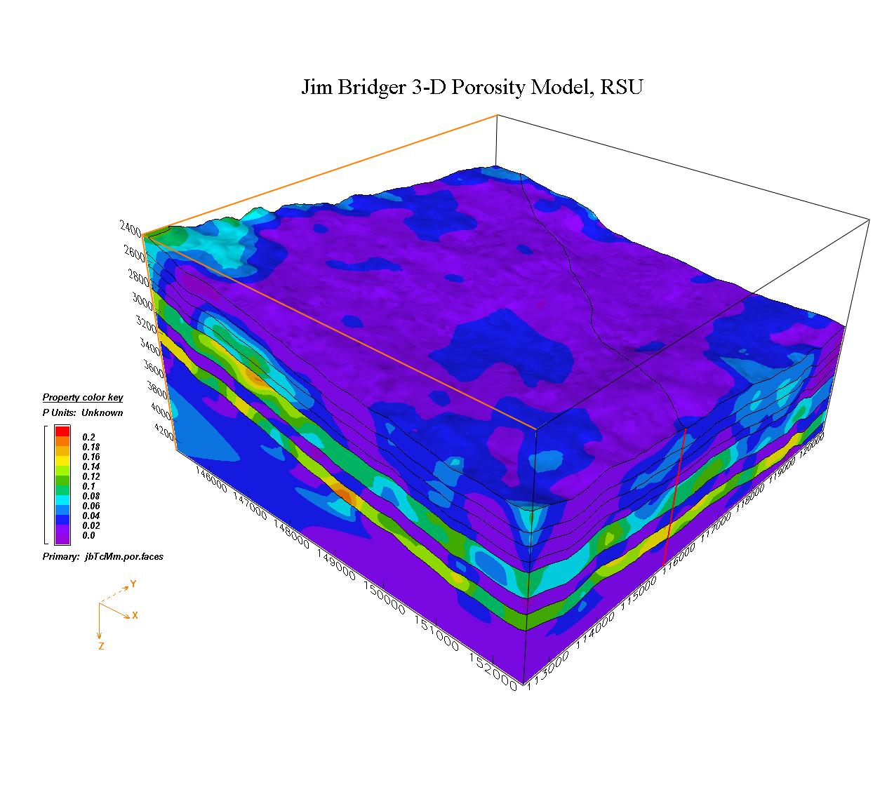
The Wyoming EV model consists of Jim Bridger structural jb3delev framework, and porosity and permeability data in jb3delev_perm and jb3delev_por.
|
EV Jim Bridger RSU Model (elevation instead of depth)
|
LaGriT Stacked Mesh 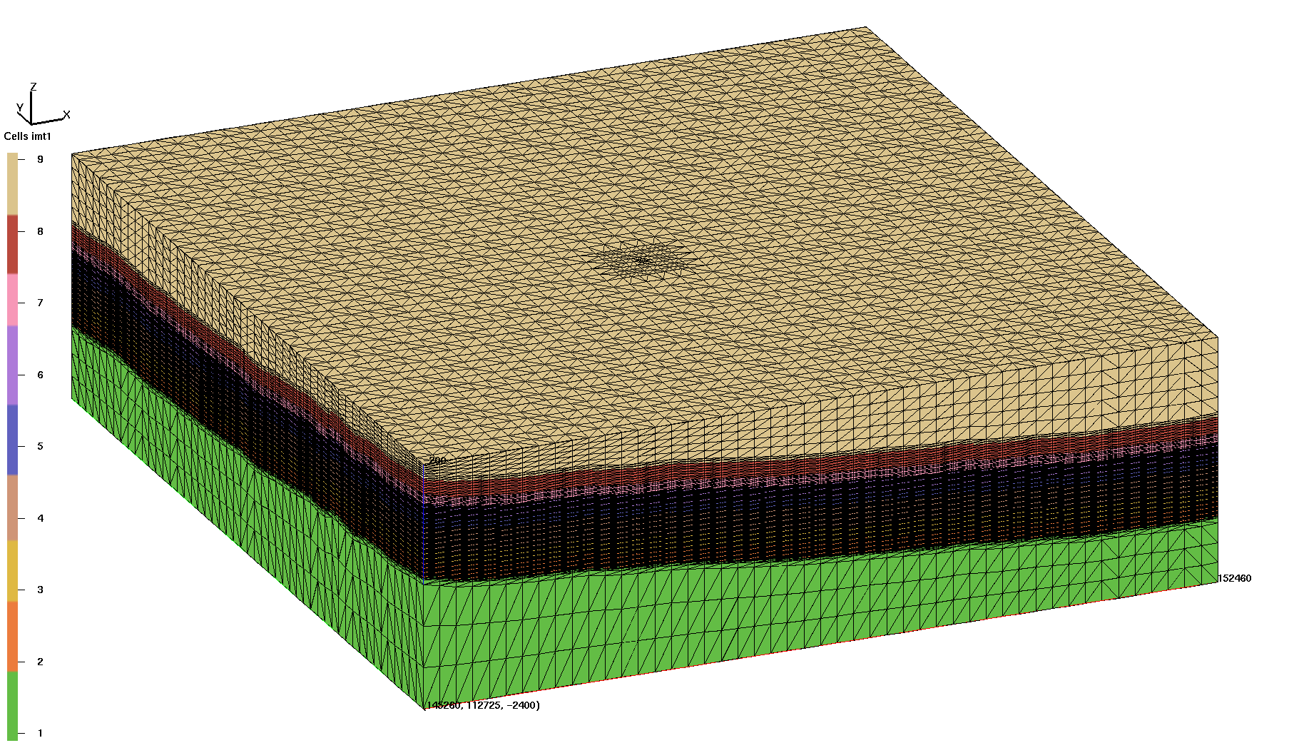
|
Mesh horizontal spacing is 150 meters, 75 m around well, and 37.5 m at well.
Vertical spacing is variable with high resolution from Madison to Redpeak.
High resolution vertical spacing near well area is between 7 and 7.8 meters.
Mesh is aligned such that well center is aligned on x,y column 148710, 116175.
Lower left corner 145260, 112725, -2400 meters
Upper right corner 152460, 120225, -200 meters
Nodes:     291954 Elements:    1851903
7200 x 7500 x 2200 meters


MESH ATTRIBUTE           MIN               MAX         DIFFERENCE    LENGTH
xic                1.452600000E+05  1.524600000E+05 7.200000000E+03    291954
yic                1.127250000E+05  1.202250000E+05 7.500000000E+03    291954
zic               -2.400000000E+03 -2.000000000E+02 2.200000000E+03    291954
imt1                             1                9               8    291954
vorvol             8.806852539E+03  8.030243000E+06 8.021436147E+06    291954
node_id            1.000000000E+00  2.919540000E+05 2.919530000E+05    291954
iwell              0.000000000E+00  5.000000000E+01 5.000000000E+01    291954

Upper units    9 has     17927 nodes. #nodes/nnodes is   0.614035092294E-01
Chugwater      8 has     17927 nodes. #nodes/nnodes is   0.614035092294E-01
Redpeak        7 has     17927 nodes. #nodes/nnodes is   0.614035092294E-01
Dinwoody       6 has     40976 nodes. #nodes/nnodes is   0.140350878239
Phosphoria     5 has     25610 nodes. #nodes/nnodes is   0.877192988992E-01
Weber          4 has     69147 nodes. #nodes/nnodes is   0.236842110753
Amsden         3 has     43537 nodes. #nodes/nnodes is   0.149122804403
Madison        2 has     43537 nodes. #nodes/nnodes is   0.149122804403
Darby          1 has     15366 nodes. #nodes/nnodes is   0.526315793395E-01

Well column   50 has     114 nodes.
                           Sum Voronoi Area_x     Area_y          Area_z
Face top     1   2561 nodes     0.9328150E+06   0.9293577E+06   0.5400000E+08
Face bottom  2   2561 nodes     0.1470623E+07   0.1355643E+07   0.5400000E+08
Face left_w  3   5814 nodes     0.1650000E+08   0.3263784E+06   0.1125000E+07
Face right_e 5   5814 nodes     0.1650000E+08   0.3294905E+06   0.1125000E+07
Face back_n  6   5586 nodes     0.3303608E+06   0.1584000E+08   0.1080000E+07
Face front_s 4   5586 nodes     0.3285473E+06   0.1584000E+08   0.1080000E+07
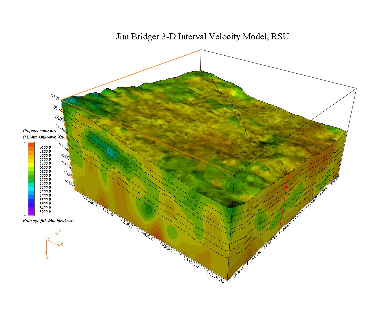
The porosity and permeability values are imported from sets of scattered point values into Earthvision and applied to each of the intervals. For this mesh, the input por and perm values are at a fine enough resolution to use interpolation directly from the input data. This skips the step of previous MOXA model which used EV to interpolate sparse data on to the EV model, then interpolated on to a set of fine resolution points - and then used upscale on to the mesh.
The input *pdat files for the EV model is used directly to interpolate perm and por values on to the computational mesh using LaGriT. The EV perm and por values of the input data points are found such that they are located on or inside the Voronoi volume and then applied to the corresponding mesh node.
PERM and POR Data
local directory /scratch/fwo/wyo_ev_models/EV3D_MAR_2012_elev_PorPerm/
perm and por values are on regular spaced x,y of 134.10 meters
z values for each unit have 230 points spread between bot and top unit surfaces
ie, for target units with thickness of 128 m, the points are 6m apart
Z Elevation
local directory /scratch/fwo/wyo_ev_models/EV3D_MAR_2012/
UNIT MIN MAX DIFFERENCE
8 chugwaterelev -1.374000000E+03 -3.500000000E+02 1.024000000E+03
7 redpeakelev -1.502000000E+03 -4.470000000E+02 1.055000000E+03
6 dinwoodyelev -1.612000000E+03 -5.510000000E+02 1.061000000E+03
5 phosphoriaelev -1.709000000E+03 -6.490000000E+02 1.060000000E+03
4 weberelev -1.850000000E+03 -7.890000000E+02 1.061000000E+03
3 amsdenelev -2.008000000E+03 -9.530000000E+02 1.055000000E+03
2 madisonelev -2.142000000E+03 -1.081000000E+03 1.061000000E+03
1 darbyelev -2.252000000E+03 -1.197000000E+03 1.055000000E+03
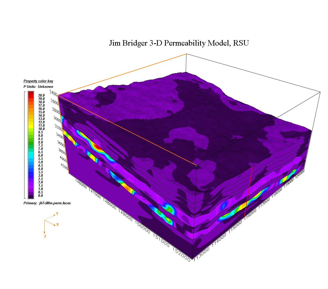
Perm Data
local directory /scratch/fwo/wyo_ev_models/EV3D_MAR_2012_elev_PorPerm/jb3delev_perm
UNIT MIN MAX DIFFERENCE NUM_POINTS
perm_chugwaterelev 1.000000000E-05 1.649200000E+00 1.649190000E+00 69612
perm_redpeakelev 1.000000000E-05 3.118000000E-01 3.117900000E-01 69594
perm_dinwoodyelev 1.000000000E-05 2.248100000E+00 2.248090000E+00 69648
perm_phosphoriaelev 1.000000000E-05 2.333000000E+00 2.332990000E+00 69681
perm_weberelev 5.000000000E-01 2.050000000E+01 2.000000000E+01 69744
perm_amsdenelev 1.000000000E-05 4.729000000E-01 4.728900000E-01 69646
perm_madisonelev 1.000000000E-05 2.000000000E+01 1.999999000E+01 69740
perm_darbyelev 1.000000000E-05 5.502000000E-01 5.501900000E-01 69676
Por Data
local directory /scratch/fwo/wyo_ev_models/EV3D_MAR_2012_elev_PorPerm/jb3delev_por
UNIT MIN MAX DIFFERENCE NUM_POINTS
por_chugwaterelev 0.000000000E+00 1.150000000E-01 1.150000000E-01 69729
por_redpeakelev 0.000000000E+00 9.100000000E-02 9.100000000E-02 69711
por_dinwoodyelev 0.000000000E+00 1.200000000E-01 1.200000000E-01 69727
por_phosphoriaelev 0.000000000E+00 1.200000000E-01 1.200000000E-01 69774
por_weberelev 0.000000000E+00 1.950000000E-01 1.950000000E-01 69744
por_amsdenelev 0.000000000E+00 9.700000000E-02 9.700000000E-02 69757
por_madisonelev 2.400000000E-02 2.360000000E-01 2.120000000E-01 69740
por_darbyelev 0.000000000E+00 9.900000000E-02 9.900000000E-02 69741
Step 1) Create template with quad background and embedded well using LaGriT scripts
         /scratch/fwo/tam/wy_2012/grid_template
        Spacing is 150m, 75m in well region, 37.5 at well location.
        This template has least number of nodes possible to allow high res stacking.
        Change well coord to integer number and translate template
        such that well center is aligned along column of background mesh
        well coord 148710, 116175

Step 2) Create material zone surfaces using LaGriT interpolate
        Extract top material elevations from EV and interpolate on to template locations.
        /scratch/fwo/wyo_ev_models/EV3D_MAR_2012_elev
        Run script foreach zone, use ev_hgbak and lagrit to write surface files.
        run_layers.scr

Step 3) Create stacked layer computational mesh
        /scratch/fwo/tam/wy_2012/grid_stack
        Stack the material surfaces extracted from EV into layers with vertical spacing as near
        to 6 meters as possible for important zones (2-6). Keep total number of nodes below 300,000.
        lagrit < stack.lgi
        Note: manually creating offset surfaces creates fully conforming interfaces
              the stack method will result in column oriented voronoi volumes

Step 3) Connect stacked points into Delaunay tet mesh.
        grid_stack/connect_pyramid
        The high ascpect ratio causes connect/delaunay to pop connections into bad ccoefs
        Use the pyramid algorithm to connect with higher precision and 0 bad ccoefs
        Note the 7m resolution is the mininum before bad ccoefs result, 10m gives best result.
        This mesh is at the 7 m resolution and does not have interface points removed.

Step 4) Apply perm and por values on to the mesh using LaGriT EV input data.
        Upscale method is not used as input data has 6m resolution, good for interpolation.
        This allows for faster completion and avoids extra interpolation steps and appears
        to be visually appropriate, and in particular, the well area looks good.
        Use perm and por input data /scratch/fwo/wyo_ev_models/EV3D_MAR_2012_elev_PorPerm
        jb3delev_perm/*pdat and jb3delev_por/*pdat

        For each mesh node of each material, apply perm or por value
        where src_val(i to n) are all source nodes found within the Voronoi cell of the sink node.
        /scratch/fwo/tam/wy_2012/fehm_grid_stackv01/pdata
        lagrit < interp_perm.lgi
        lagrit < interp_por.lgi

Step 5) write final fehm files and the perm and por attributes for the mesh
        /scratch/fwo/tam/wy_2011/fehm_grid_vers02
        lagrit < fehm_files.lgi
/scratch/fwo/wyo_ev_models/EV3D_MAR_2012_elev/jb3dele.seq
/scratch/fwo/wyo_ev_models/EV3D_MAR_2012_elev_PorPerm/jb3delev_perm/perm*input.pdat
/scratch/fwo/wyo_ev_models/EV3D_MAR_2012_elev_PorPerm/jb3delev_por/por*input.pdat
/scratch/fwo/tam/wy_2012/fehm_grid_stackv01

tet.inp -> /scratch/fwo/tam/wy_2012/grid_stack/connect_pyramid/tet_connect.inp
tet.gmv -> /scratch/fwo/tam/wy_2012/grid_stack/connect_pyramid/tet_connect.gmv

-rw-r--r-- 1 tam pf      2091 Apr 12 08:18 README
drwxr-xr-x 2 tam pf      4096 Apr 12 07:49 images/

-rw-r--r-- 1 tam pf  96656811 Apr 11 16:30 tet.fehmn
-rw-r--r-- 1 tam pf 117917877 Apr 11 16:31 tet_zero.stor
-rw-r--r-- 1 tam pf   3211803 Apr 11 16:30 tet_material.zone
-rw-r--r-- 1 tam pf   6195854 Apr 11 16:30 tet_multi_mat.zone
-rw-r--r-- 1 tam pf    307399 Apr 11 16:30 tet_outside.zone
-rw-r--r-- 1 tam pf   1773701 Apr 11 16:30 tet_outside_vor.area
-rw-r--r-- 1 tam pf      1299 Apr 11 16:30 tet_well_material.zone
-rw-r--r-- 1 tam pf  32115147 Apr 11 16:30 node_attributes.dat
-rw-r--r-- 1 tam pf      6708 Apr 11 16:30 well_attributes.dat

Mesh Views
-rw-r--r-- 1 tam pf  80682704 Apr 11 16:30 tet_fehm.gmv
-rw-r--r-- 1 tam pf  16894192 Apr 12 07:54 tet_surfmesh.gmv
-rw-r--r-- 1 tam pf  12721672 Apr 12 07:55 tet_surfmesh_Yslice.gmv
-rw-r--r-- 1 tam pf  12267276 Apr 12 07:55 tet_surfmesh_Xslice.gmv
-rw-r--r-- 1 tam pf      5768 Apr 11 16:30 well_points.gmv

LAGRIT Files
-rw-r--r-- 1 tam pf       697 Apr 12 07:54 extract_surfmesh.lgi
-rw-r--r-- 1 tam pf     19624 Apr 12 08:05 extract_surfmesh.out
-rw-r--r-- 1 tam pf     45454 Apr 11 16:31 fehm_files.out
-rw-r--r-- 1 tam pf      5589 Apr 11 16:31 fehm_files.log
-rw-r--r-- 1 tam pf      2813 Apr 11 16:29 fehm_files.lgi


por and perm values from mesh:

-rw-r--r--  1 tam  tam    537911 Apr 13 11:37 perm_mat01.dat
-rw-r--r--  1 tam  tam   1610970 Apr 13 11:37 perm_mat02.dat
-rw-r--r--  1 tam  tam   1610970 Apr 13 11:37 perm_mat03.dat
-rw-r--r--  1 tam  tam   2558540 Apr 13 11:37 perm_mat04.dat
-rw-r--r--  1 tam  tam    922061 Apr 13 11:37 perm_mat05.dat
-rw-r--r--  1 tam  tam   1516213 Apr 13 11:37 perm_mat06.dat
-rw-r--r--  1 tam  tam    645473 Apr 13 11:37 perm_mat07.dat
-rw-r--r--  1 tam  tam    645473 Apr 13 11:37 perm_mat08.dat
-rw-r--r--  1 tam  tam    537910 Apr 13 11:37 por_mat01.dat
-rw-r--r--  1 tam  tam   1610969 Apr 13 11:37 por_mat02.dat
-rw-r--r--  1 tam  tam   1610969 Apr 13 11:37 por_mat03.dat
-rw-r--r--  1 tam  tam   2558539 Apr 13 11:37 por_mat04.dat
-rw-r--r--  1 tam  tam    922060 Apr 13 11:37 por_mat05.dat
-rw-r--r--  1 tam  tam   1516212 Apr 13 11:37 por_mat06.dat
-rw-r--r--  1 tam  tam    645472 Apr 13 11:37 por_mat07.dat
-rw-r--r--  1 tam  tam    645472 Apr 13 11:37 por_mat08.dat

==> perm_mat02.dat <==
Each file has a header and 3 fields; line number, mesh node id, perm or por value

         0          0          2          0          0
00002  1  1
node_id, integer
vor_perm, real
       1   15367  0.116195000000E+02
       2   15368  0.108365000000E+02
       3   15369  0.200000000000E+02

==> por_mat02.dat <==
         0          0          2          0          0
00002  1  1
node_id, integer
vor_por, real
       1   15367  0.149000000000E+00
       2   15368  0.148000000000E+00
       3   15369  0.174000000000E+00
|
Hex Mesh with Fault Images (Scoping Mesh)
|
Use the same surfaces as used for the refined tet mesh,
but without the refinement. The result is a hex mesh with the
same spacing as the background version of the refined tet mesh.

Horizontal spacing is 150 meters. Vertical is variable and based
on layers in relation to the Earthvision surfaces.

Mesh extents (meters) are the same as the tet mesh.
   MIN       MAX      DIFFERENCE
x  145260   152460    7200
y  112725   120225    7500
z   -2400     -200    2200


Both the tet and the hex mesh have the same node numbering starting
with node 1 at the lower left corner and node 284886 at upper right.
Zone files were written for unit materials, well, and fault.

hex.inp 284886 nodes,  271200 hex elements
tet.inp 284886 nodes, 1807182 tet elements

cp /scratch/fwo/tam/wy_2012/grid_stack/connect_pyramid/RUNS .
cp /scratch/fwo/tam/wy_2012/grid_stack/connect_pyramid/*lgi .
cp /scratch/fwo/tam/wy_2012/grid_stack/connect_pyramid/*awk .
cp /scratch/fwo/tam/wy_2012/grid_stack/connect_pyramid/*attr .

*** Construct and Compress Sparse Matrix:3D ***
   *** Compress Area Coefficient Values ***
AMatbld3d_stor: *****Zero Negative Coefficients ******
AMatbld3d_stor: Number of 'zero' (< 10e-8*max) coefs    5865
AMatbld3d_stor: npoints =   284886  n connections =    4385836
AMatbld3d_stor: Number of written coefs =    551188
AMatbld3d_stor: Maximum num. connections to a node =         25
AMatbld3d_stor: Volume min =   4.0703730E+04
AMatbld3d_stor: Volume max =   8.0302428E+06
AMatbld3d_stor: Total Volume:   1.1880002E+11
AMatbld3d_stor: abs(Aij/xij) min =   2.7694223E-05
AMatbld3d_stor: abs(Aij/xij) max =   3.2787372E+03
AMatbld3d_stor: (Aij/xij) max =  -2.7694223E-05
AMatbld3d_stor: (Aij/xij) min =  -3.2787372E+03
Compression used for graph and coefficient values
The area coefficient values were written as scalar area/distance
ascii STOR file written with name tet_zero.stor

*********dump_material_lists********
Minimum material ID value =      1
Maximum material ID value =      9
Total possible materials  =      9
Material           1 has     14994 nodes. #nodes/nnodes is   0.526315793395E-01
Material           2 has     42483 nodes. #nodes/nnodes is   0.149122804403
Material           3 has     42483 nodes. #nodes/nnodes is   0.149122804403
Material           4 has     67473 nodes. #nodes/nnodes is   0.236842110753
Material           5 has     24990 nodes. #nodes/nnodes is   0.877192988992E-01
Material           6 has     39984 nodes. #nodes/nnodes is   0.140350878239
Material           7 has     17493 nodes. #nodes/nnodes is   0.614035092294E-01
Material           8 has     17493 nodes. #nodes/nnodes is   0.614035092294E-01
Material           9 has     17493 nodes. #nodes/nnodes is   0.614035092294E-01

Well zone points are the same location as in the tet mesh.
Located in a x,y column at 148710, 116175 from -2400 to -200 elevation.
Zone Material Well         50 has      114 nodes

Fault zone created with surface from Earthvision model
as defined in /scratch/fwo/wyo_ev_models/EV3D_MAR_2012_elev/jb3dele.seq
/scratch/fwo/wyo_ev_models/EV3D_MAR_2012_elev/jb3dele/fault
ev_export -o fault_f1.dat f1elev.2grd

Zone Material Full  Fault  20 has     17674 nodes
Zone Material South Side   21 has      8955 nodes
Zone Material North Side   22 has      8719 nodes

Hex Mesh converted to tet for FEHM Files

/scratch/fwo/tam/wy_2012/fehm_hex_stackv01

lrwxrwxrwx 1 tam pf           71 Aug  7 12:06 tet.inp
-> /scratch/fwo/tam/wy_2012/grid_stack_hex/connect_pyramid/tet_connect.inp

-rw-r--r-- 1 tam sftus  31337667 Aug  7 12:40 node_attributes.dat
-rw-r--r-- 1 tam sftus  94321422 Aug  7 12:41 tet.fehmn
-rw-r--r-- 1 tam sftus   3134055 Aug  7 12:41 tet_material.zone
-rw-r--r-- 1 tam sftus   6116174 Aug  7 12:41 tet_multi_mat.zone
-rw-r--r-- 1 tam sftus    306035 Aug  7 12:41 tet_outside.zone
-rw-r--r-- 1 tam sftus   1765827 Aug  7 12:41 tet_outside_vor.area
-rw-r--r-- 1 tam sftus      1299 Aug  7 12:42 tet_well_material.zone
-rw-r--r-- 1 tam sftus      6708 Aug  7 12:42 well_attributes.dat

Hex Mesh for Stress Calculations
-rw-r--r-- 1 tam sftus  41081989 Aug  7 14:13 hex.inp
-rw-r--r-- 1 tam sftus  25793816 Aug 22 14:28 hex.gmv
-rw-r--r-- 1 tam sftus    194459 Aug 29 16:23 fault_material.zone
-rw-r--r-- 1 tam sftus     95954 Aug 29 16:23 fault_north_material.zone
-rw-r--r-- 1 tam sftus     98550 Aug 29 16:23 fault_south_material.zone

-rw-r--r-- 1 tam pf         3466 Aug 30 08:02 README

drwxr-xr-x 2 tam sftus      4096 Aug 30 07:44 fault/
drwxr-xr-x 2 tam pf         8192 Aug 30 07:58 images/

Visualization Files
-rw-r--r-- 1 tam pf         5589 Aug  7 12:45 fehm_files.log
-rw-r--r-- 1 tam pf        45539 Aug  7 12:45 fehm_files.out
-rw-r--r-- 1 tam pf        61378 Aug  7 13:49 stack_hex.jpg
-rw-r--r-- 1 tam pf       107535 Aug  7 13:50 stack_hex.rgb
-rw-r--r-- 1 tam sftus      5768 Aug  7 12:42 well_points.gmv
-rw-r--r-- 1 tam sftus  78733484 Aug  7 12:42 tet_fehm.gmv
-rw-r--r-- 1 tam sftus  16820352 Aug  7 12:42 tet_surfmesh.gmv
|
Brick Mesh Zone Materials 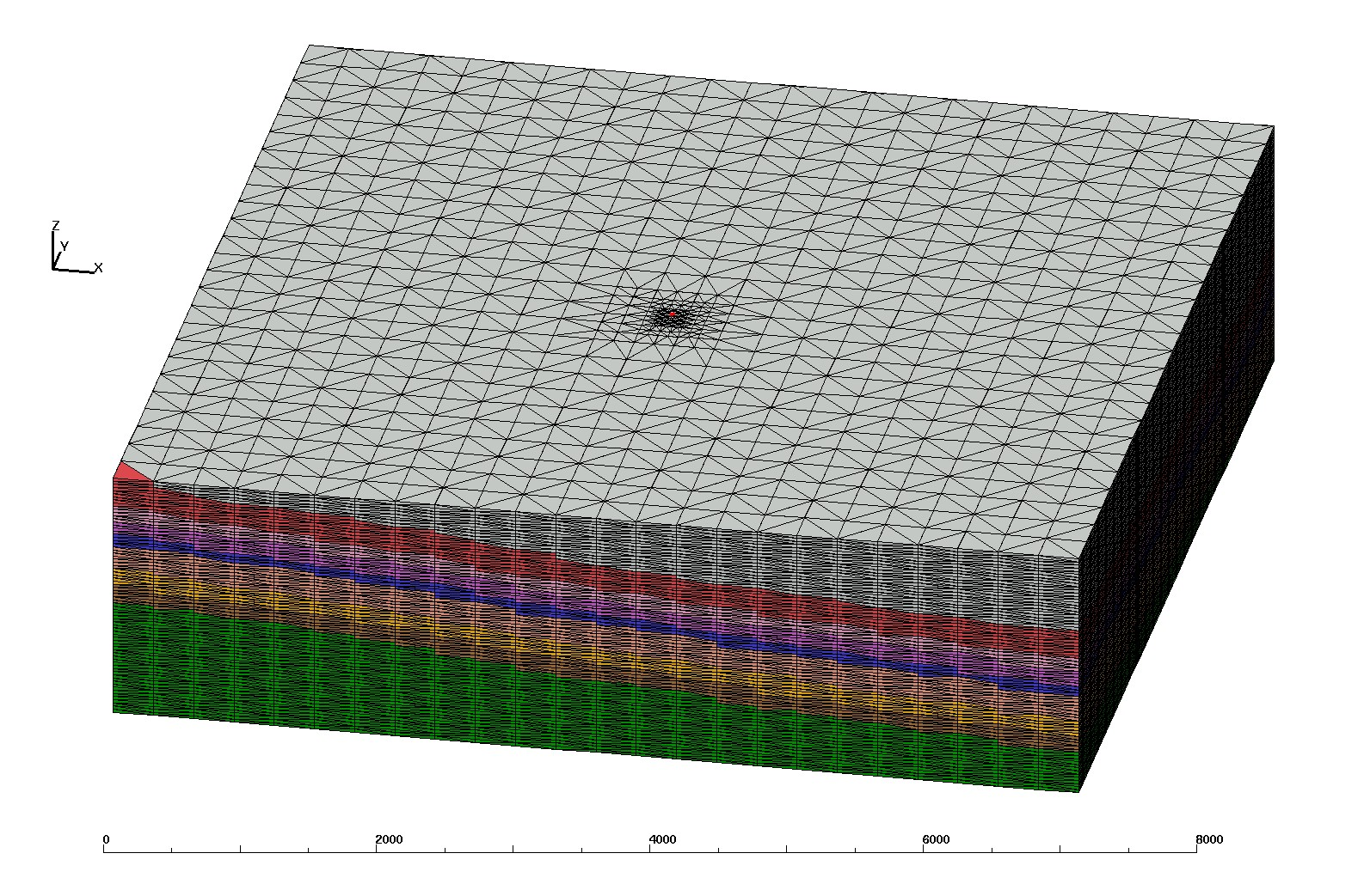
|
This is a quick and coarse version of the mesh with 300x300x25 regular spacing for scoping purposes. Interpolate
was used for perm and por values instead of the more complicated upscale method.
This Brick Mesh was created using LaGriT input files and Earthvision on the command line to query material zone values for the mesh point locations.
number of nodes = 58444 number of elements = 323089
This scoping mesh is regular spacing with vertical refinement to well node
300 x 300 meter horizontal, refined by halves to well area with
25.33 vertical resolution. Well nodes are tagged as closest column to actual location.
Well coordinates for this coarse mesh are at 148687.50, 116187.50.
* 7200 x 7500 x 1900
define X0 145200.
define X1 152400.
define Y0 112700.
define Y1 120200.
define Z0 -2200.
define Z1 -300.

Upper units 9 has     17924 nodes. #nodes/nnodes is   0.306686720000
Chugwater   8 has      4731 nodes. #nodes/nnodes is   0.809492840000E-01
Redpeak     7 has      2992 nodes. #nodes/nnodes is   0.511943100000E-01
Dinwoody    6 has      3512 nodes. #nodes/nnodes is   0.600917110000E-01
Phosphoria  5 has      2360 nodes. #nodes/nnodes is   0.403805330000E-01
Weber       4 has      6081 nodes. #nodes/nnodes is   0.104048310000
Amsden      3 has      3865 nodes. #nodes/nnodes is   0.661316810000E-01
Madison     2 has      3942 nodes. #nodes/nnodes is   0.674491820000E-01
Darby       1 has     13037 nodes. #nodes/nnodes is   0.223068230000

Well       50 has        76 nodes.
/scratch/fwo/tam/wy_2012/grid_brick

-rw-r--r--  1 tam  tam  22666225 Mar 22 11:16 tet_connect.inp
-rw-r--r--  1 tam  tam  15841856 Mar 22 11:16 tet_connect.gmv

-rw-r--r--  1 tam  tam  11312320 Mar 22 11:17 tet_zero.stor
-rw-r--r--  1 tam  tam  17396227 Mar 22 11:16 tet.fehmn
-rw-r--r--  1 tam  tam   1321559 Mar 22 11:16 tet_multi_mat.zone
-rw-r--r--  1 tam  tam    102361 Mar 22 11:16 tet_outside.zone
-rw-r--r--  1 tam  tam    590483 Mar 22 11:16 tet_outside_vor.area
-rw-r--r--  1 tam  tam    643069 Mar 22 11:16 tet_material.zone
-rw-r--r--  1 tam  tam       865 Mar 22 11:16 tet_well_material.zone

-rw-r--r--  1 tam  tam   6429047 Mar 22 11:16 node_attributes.dat
-rw-r--r--  1 tam  tam      6328 Mar 22 11:16 well_attributes.dat


Note: upscale values near refined well area do not look as good as interpolated values

each file has lineno, node_id, gperm_md, hperm_md, gperm_m2, hperm_m2, perm_near

gperm_md = geometric upscale
hperm_md = harmonic upscale
perm_near is interpolation of perm to nearest input data perm
gperm_m2 = gperm_md mult by 1e-15
hperm_m2 = hperm_md mult by 1e-15


-rw-r--r--  1 tam  tam  1512470 Mar 29 12:27 perm_mat01.dat
-rw-r--r--  1 tam  tam   457450 Mar 29 12:27 perm_mat02.dat
-rw-r--r--  1 tam  tam   448518 Mar 29 12:27 perm_mat03.dat
-rw-r--r--  1 tam  tam   705574 Mar 29 12:27 perm_mat04.dat
-rw-r--r--  1 tam  tam   271578 Mar 29 12:27 perm_mat05.dat
-rw-r--r--  1 tam  tam   407570 Mar 29 12:27 perm_mat06.dat
-rw-r--r--  1 tam  tam   344258 Mar 29 12:27 perm_mat07.dat
-rw-r--r--  1 tam  tam   548974 Mar 29 12:27 perm_mat08.dat
| Carl Gable | gable -at- lanl -dot- gov | 505-665-3533 |
| Terry Miller | tamiller -at- lanl -dot- gov | 505-667-8009 |