Grid Project: Pajarito Basin Seismic Model
| Grid Team Member: |
Terry Miller |
| Grid Versions: |
Prototypes V01 and V02 |
| Data Source: |
Cole 2005 Basin GFM |
| Delivered To: |
Carene Larmat and Richard Lee EES-17 |
| Date Completed: |
Dec 4 2013 |
Images of Full Pajarito ARC Surfaces
Images of Cropped Pajarito GFM
Images of V01 Large Coarse Mesh
Images of V02 Small Mesh
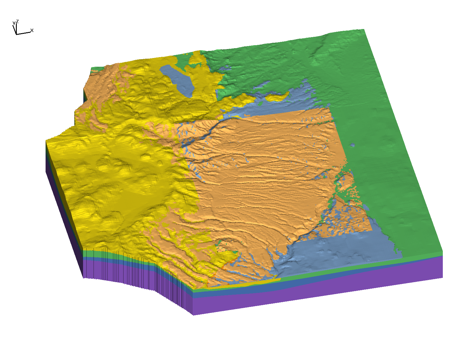
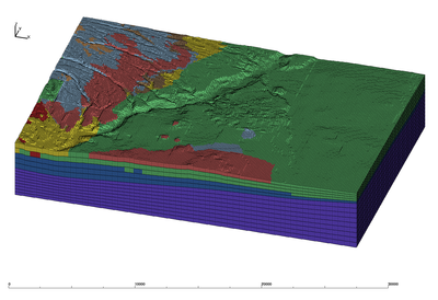
Subset Basin Surfaces GFM 2005
|
Subset Stratigraphic Volumes
|
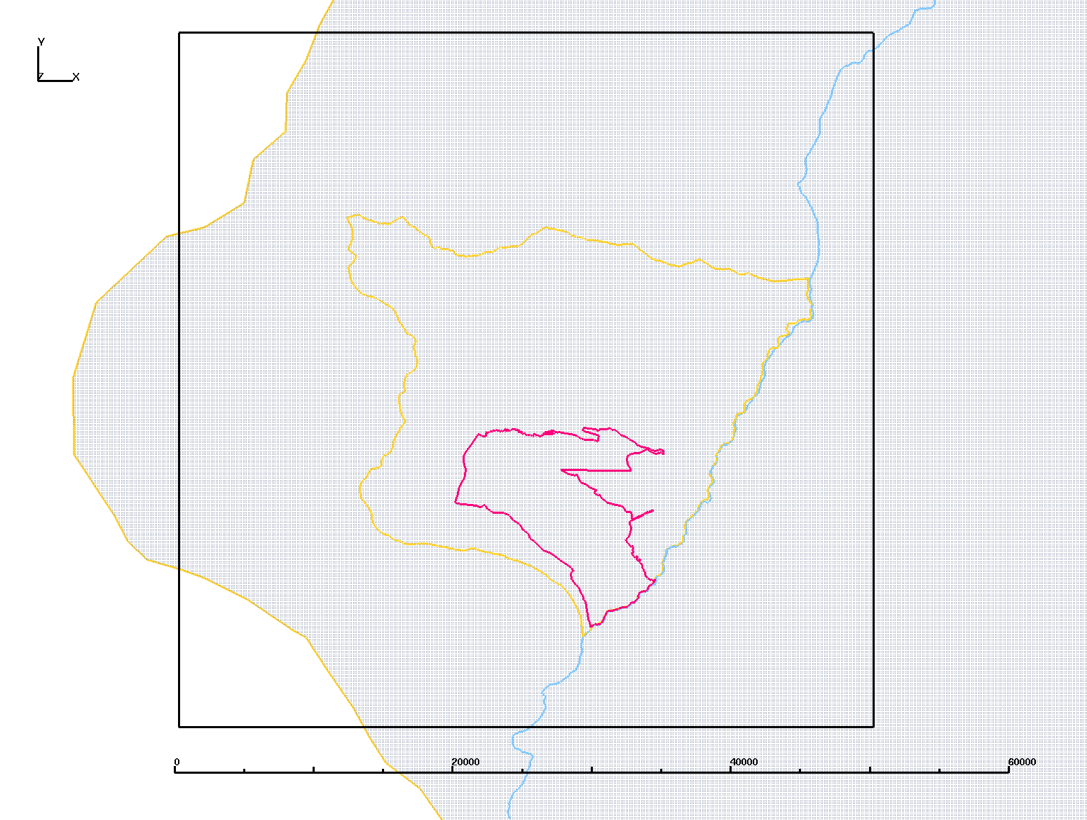
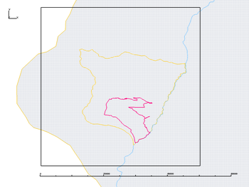
   Image shows subset domain (black box)
   Rio Grande (blue)
   Infiltration Boundary (yellow)
   LANL Boundar (red)
   Basin Surface (gray background)

   Subset Extents (Meters):
    XMIN 470000.  XMAX 520000.
    YMIN 520000.  YMAX 570000.
|
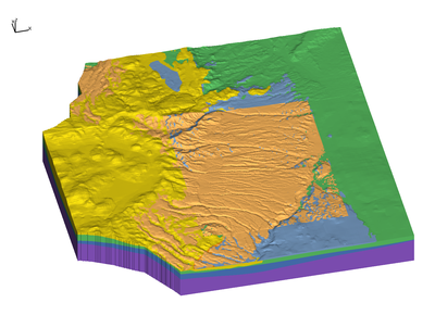
   S8  QBT - Bandelier Tshirege Members (tan)
   S7  TPF - Puye Fanglomerate (blue)
   S6  TPT - Totavi, basal conglomerate of TPF (brown)
   S5  TF  - Santa Fe Fanglomerate (yellow)
   S4  TSF - Santa Fe Silt and Sands (green)
   S3  PAL - Older Sedimentary (dark blue)
   S2  PcF - NONE in this Domain
   S1  Pc  - Pre-Cambrian (purple)

   F7  TB4 - Basalt in TPF (red)
   F5  TK  - Keres Group in TF (dark red)

   S = Stratigraphic Layer
   F = Flow Body within a Stratigraphic Layer
|
Purpose of Project
Build a seismic model for the Pajarito Basin using a Geologic Framework Model to identify material layers.
The model includes all GFM materials including the deep Precambrian layer.
There may be more detailed geophysics in the future (seismic reflection) for defineing structure in the Santa Fe/Precambrian interface.
Primary Tasks
Process and document the Basin Geologic Framework (GFM) for the study area. There are two versions of Basin Surfaces. The 2005 version includes fault structure. These were updated in 2009 but do not include the faults and have not been evaluated. The 2005 Basin surfaces are used for this model.
Develop a process to export mesh and model setup information from LaGriT to SPECFEM3D. The modeling and import/export process contact Carene Larmat EES-17.
Some questions:
-How are units defined? Depending on the criteria used for the definition of units, we might want to merge some units together for a wave propagation code.
- Can LaGrit be used to create a mesh without degenerate elements? Or can elements that are degenerate be modified to work with SPECFEM?
- Which format(s) can the mesh be exported? Can they be used to import the mesh into SPECFEM3D?
-How easy would it be to modify the elastic properties in each units? The goal of this project is to explore the effects of the uncertainty we have on the velocity structure.
Build a computational mesh for seismic modeling SPECFEM3D Software. Develop strategies for mesh generation that respect the computational specifications for SPECFEM3D. The mesh is made of hexahedral elements and can not contain degeneracies such as pinch-outs or zero volume elements.
Come up with a plan/strategy for 'pinch outs'. Due to the nature of the geology (tuff and basalt flows in the upper units and alluvium in the deeper units) there are places where units disappear.
The geologic model (GFM) is based on surfaces is represented by continuous surfaces Z(x,y) where every surface has the exact same (x,y) mesh template and each surface has different Z values. Where a unit does not exist Z_top-Z_bottom=0. Also, units are discontinuous since the canyons have cut into the units to expose the outcrop pattern we see.
Apply properties based on GFM materials for modeling with SPECFEHM3D Software. Properties are included in Excel Spreadsheet provided by Richard C Lee.
Excel Spreadsheet Data:
FEM_unit_properties1.xlsx
Prototype Method
Initial strategy is the selection of basin surfaces that do not intersect or pinch-out. These surfaces are used to create a stacked hex mesh that follow the shape of surfaces used. The GFM materials are interpolated on to the hex mesh elements. These first prototypes will have coarse vertical resolution and materials will stair-step along all interfaces except those that were used in the stacking of the layers.
Step 1. Select basin surfaces that do not pinchout.
|
Step 2. Construct layers between surfaces and stack.
|
Step 3. Fill layers with hexahedral elements.

|
Step 4. Interpolate GFM materials on to hex elements.
|
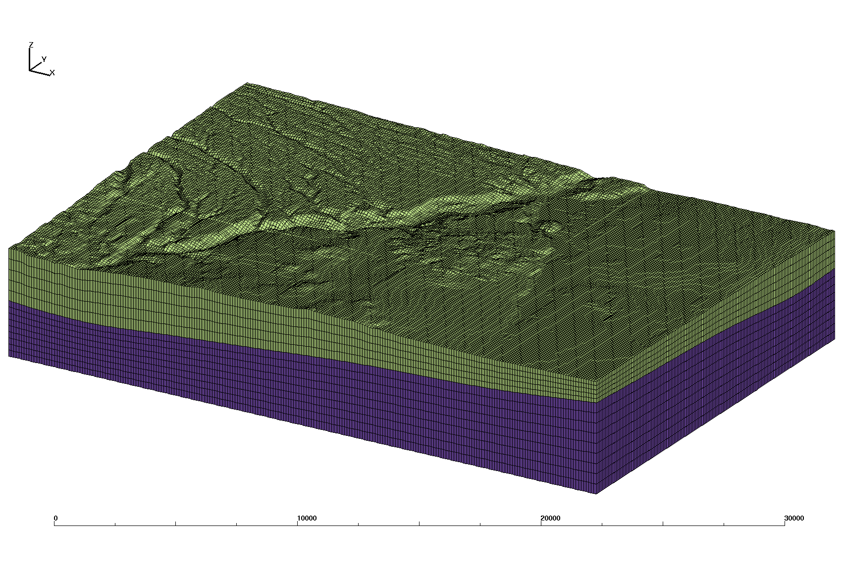
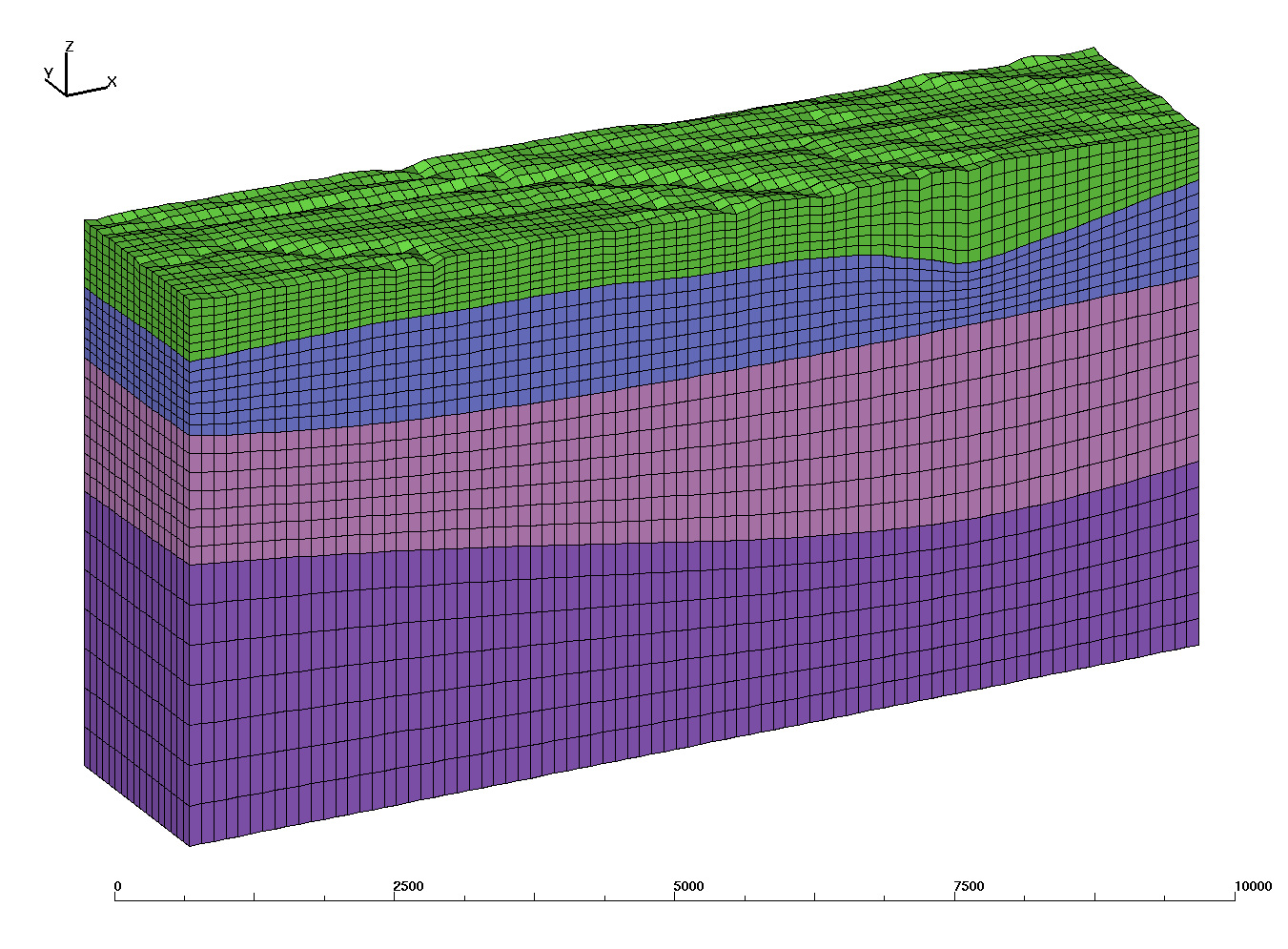
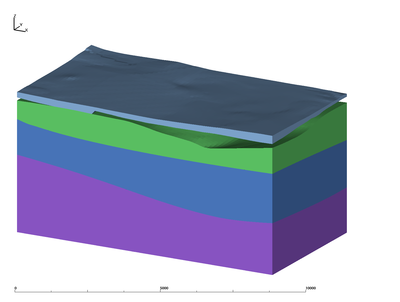
Proto Mesh V01 Coarse with Rio Grande
This domain is medium in size but coarse in vertical resolution. Only 2 basin surfaces can be used for the mesh as all others pinch-out or are discontinuous across the features of mesas and the Rio Grande.
The bottom surface is a flat -3000 meter elevation.
Images of V01 Large Coarse Mesh
Stacked Hex Mesh

|
Interpolated Hex Mesh
|
Stacked basin surfaces:

      ---  09S_topo_b

    2

      ---  03S_pal_b

    1

      ---  bottom
|
    Interpolated basin materials:
      ---  09S_topo_b
    9 tk
    8 tb4
    7 qbt
    6 tpf
    5 tpt
    4 tf
    3 tsf
    2 pal
      ---  03S_pal_b
    1 pc
      ---  bottom
|
|
Proto V01 Mesh Description:
Coarse mesh with domain across the Rio Grande
Mesh xy spacing is same as input surfaces 121.92 meters (400 feet).
Mesh vertical spacing is variable and near 200 meters.

546360 nodes
504504 hex elements

Mesh extents:

ATTRIBUTE     MIN               MAX           DIFFERENCE
 xic      4.919472000E+05  5.201107200E+05   2.816352000E+04
 yic      5.199888000E+05  5.390083200E+05   1.901952000E+04
 zic     -3.000000000E+03  2.299021866E+03   5.299021866E+03
Proto V01 Mesh Files:
/scratch/sft/tam/grid_gen/SPECFEM3D/proto_v01_rio

Layer mesh (no stair-steps)
-rw-r--r-- 1 tamiller sft  33958460 Dec  3 13:35 hex_2mat.exo
-rw-r--r-- 1 tamiller sft 175694864 Dec  3 13:36 hex_2mat.exo.avs
-rw-r--r-- 1 tamiller sft  58953240 Dec  3 13:36 hex_2mat.exo.gmv

Layer mesh with interpolated GFM (stair-steps)
-rw-r--r-- 1 tamiller sft  33960736 Dec  3 14:23 hex_allmat.exo
-rw-r--r-- 1 tamiller sft 216055269 Dec  3 14:24 hex_allmat.exo.avs
-rw-r--r-- 1 tamiller sft  73054264 Dec  3 14:24 hex_allmat.exo.gmv
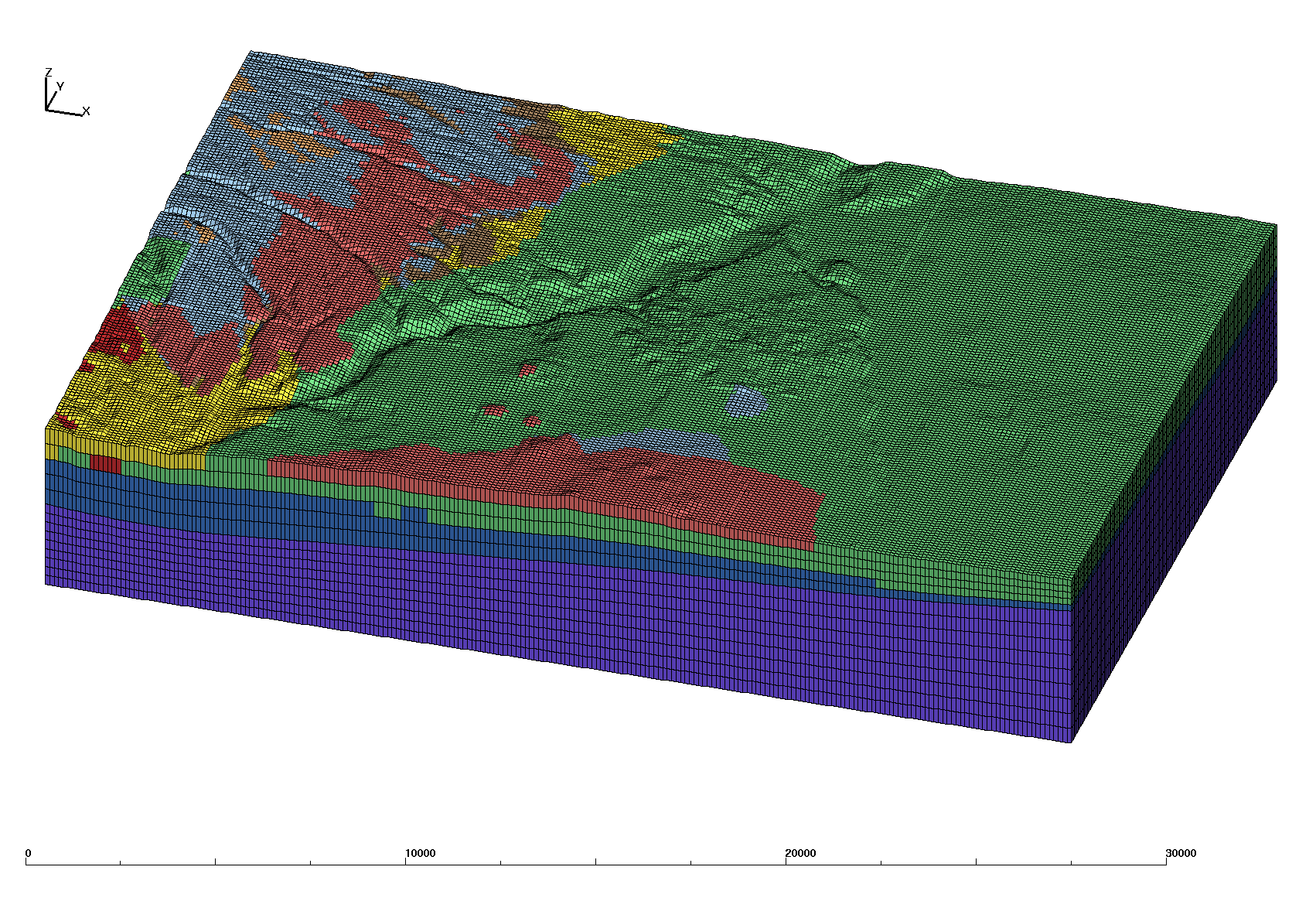
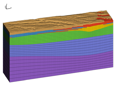
Proto Mesh V02 Small
This domain is small and located within LANL boundary. 4 basin surfaces
are used for the mesh.
The bottom surface is a flat -3000 meter elevation.
Images of V02 Small Mesh
Stacked Hex Mesh
|
Interpolated Hex Mesh
|
    Stacked basin surfaces:

      ---  09S_topo_b
    4
      ---  05S_tf_b
    3
      ---  04S_tsf_b
    2
      ---  03S_pal_b
    1
      ---  bottom
|
    Interpolated basin materials:

      ---  09S_topo_b
    8 tb4
    7 qbt
    6 tpf
    5 tpt
    4 tf
      ---  05S_tf_b
    3 tsf
      ---  04S_tsf_b
    2 pal
      ---  03S_pal_b
    1 pc
      ---  bottom
|
|
Proto V02 Mesh Description:
Small Domain mesh within LANL boundary
Mesh xy spacing is same as input surfaces 121.92 meters (400 feet).
Mesh vertical spacing is variable and near 120 meters.

43848 nodes
39508 hex elements

Mesh extents:
ATTRIBUTE         MIN               MAX        DIFFERENCE
 xic      4.919472000E+05  5.020665600E+05   1.011936000E+04
 yic      5.369356800E+05  5.390083200E+05   2.072640000E+03
 zic     -3.000000000E+03  2.299021866E+03   5.299021866E+03
Proto V02 Mesh Files:
/scratch/sft/tam/grid_gen/SPECFEM3D/proto_v02_small
Layer mesh (no stair-steps)
-rw-r--r-- 1 tamiller sft  2703092 Dec  3 09:32 hex_4mat.exo
-rw-r--r-- 1 tamiller sft 13593244 Dec  3 09:32 hex_4mat.exo.avs
-rw-r--r-- 1 tamiller sft  4929816 Dec  3 09:32 hex_4mat.exo.gmv

Layer mesh with interpolated GFM (stair-steps)
-rw-r--r-- 1 tamiller sft  2704392 Dec  3 09:41 hex_allmat.exo
-rw-r--r-- 1 tamiller sft 16753969 Dec  3 09:41 hex_allmat.exo.avs
-rw-r--r-- 1 tamiller sft  6040264 Dec  3 09:41 hex_allmat.exo.gmv
Grid Team Contacts
| Carl Gable |
gable -at- lanl -dot- gov |
505-665-3533 |
| Terry Miller |
tamiller -at- lanl -dot- gov |
505-667-8009 |