Grid Project:
Barrow Ice Wedge
Polygon 06
V3.2.0.C.1 (fine scale)
| Grid Team Member: |
Lucia Short |
| Grid Version: |
Version 03.2.0.C.1: single polygon #6 |
| Data Source: |
LiDAR data Area C from Chandana Gangodagamage |
| Delivered To: |
Scott Painter |
| Date Completed: |
November 6, 2013 |
| |
|
| V3.2.0.C.1 Mesh (6 layers): |
229,284 Nodes and |
435,968 Cells |
Purpose of Project
These meshes were developed in support of the Arctic Next Generation Ecosystem Experiment (NGEE-Arctic) Project and LANL Laboratory Directed project LDRD20120068DR. These two projects share a need for high quality computational meshes for use in fine-scale modeling of thermal hydrology in ice-wedge polygon landscapes.
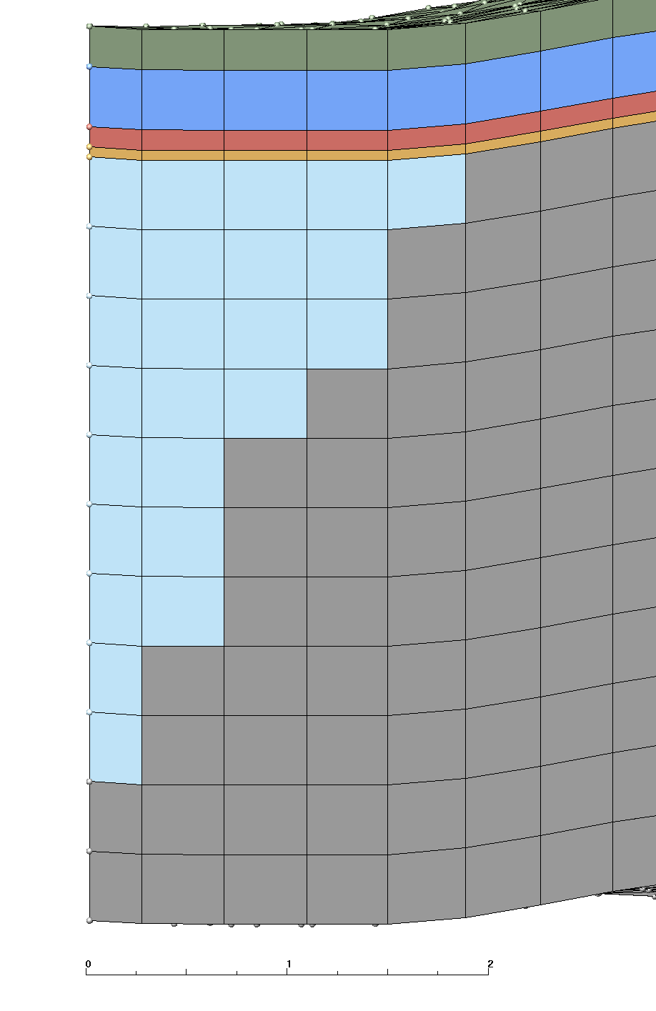
Version 3.2.C.1 runs the Version 3.C.# extending the deep mineral layer (layer 6) to -45 deep. This mesh is 3D based on single polygon #6 generated using LiDAR data set (area C). This mesh follows the criteria listed in the Mesh Input Parameters below. The mesh has 1 moss layer, 2 organic layers, and 3 mineral layers with a flat bottom. The Ice Wedge starts at the top of the mineral layers and is aprox 2.8 meters long. The convention of layer order numbering is from top to bottom. Two Exodus II mesh files are written, one multi-material with ice, and one single material.
The layers above ice have a constant thickness throughout the mesh. The bottom layers (mineral 5 and 6) have variable thickness where ice material replaces mineral material. The bottom layer (mineral 6) is exteded to -45 in this version.
Changes in Files
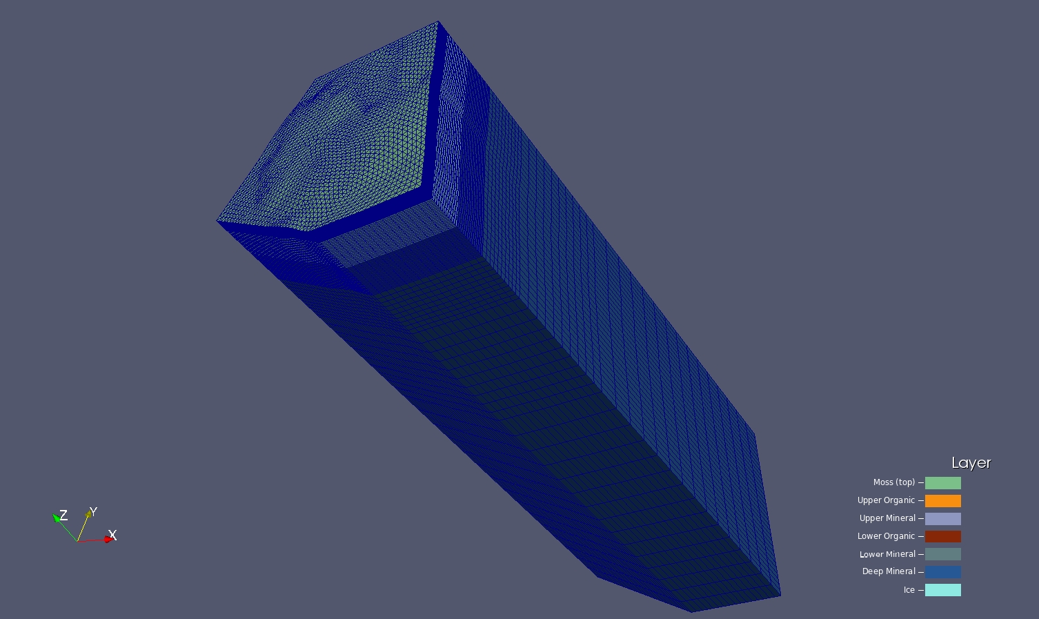
This version is running V3.0.2 (arctic_fine_v3_1_poly06) single polygon 06. The bottom layer (mineral 6) was extended to -45 m deep. The layer 6 has nonuniform mesh with vertical spasing (resolution) as folloing:
5 m deep with 50 cells,
4 m deep with 10 cells,
10 m deep with 10 cells,
30 m deep with 15 cells,
bottom is at -45.
File stack_full_poly.lgi:
< define / Z_BOTTOM / -45.

. . .

< # L5 --------------------- tmp_lay5.inp 5,49
< #     mat 6 =  variable ? / 5 thick now
< # L6 --------------------- tmp_lay6.inp 6,9
< #     mat 6 =  4. thick
< # L7 --------------------- tmp_lay7.inp 7,9
< #     mat 6 = 10.thick
< # L8 --------------------- tmp_lay8.inp 8,14
< #     mat 6 = 30.thick
< # BOT--------------------- tmp_lay_bot.inp 9

. . .

< 	  tmp_lay8.inp    6,14 &
< 	  tmp_lay7.inp    6,9  &
<    tmp_lay6.inp    6,9  &
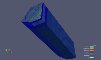
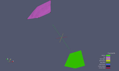
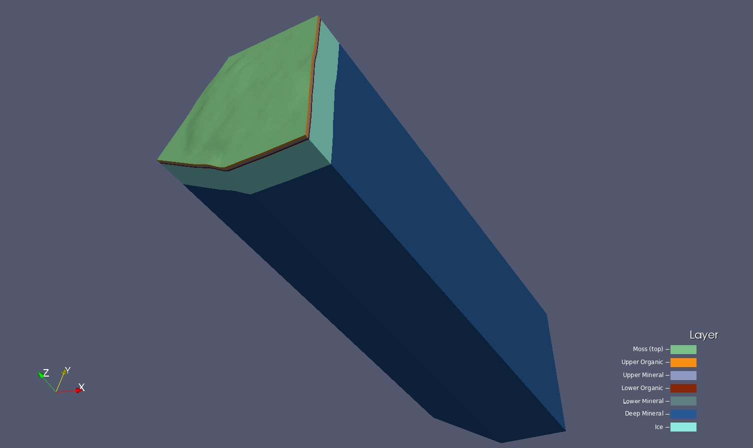
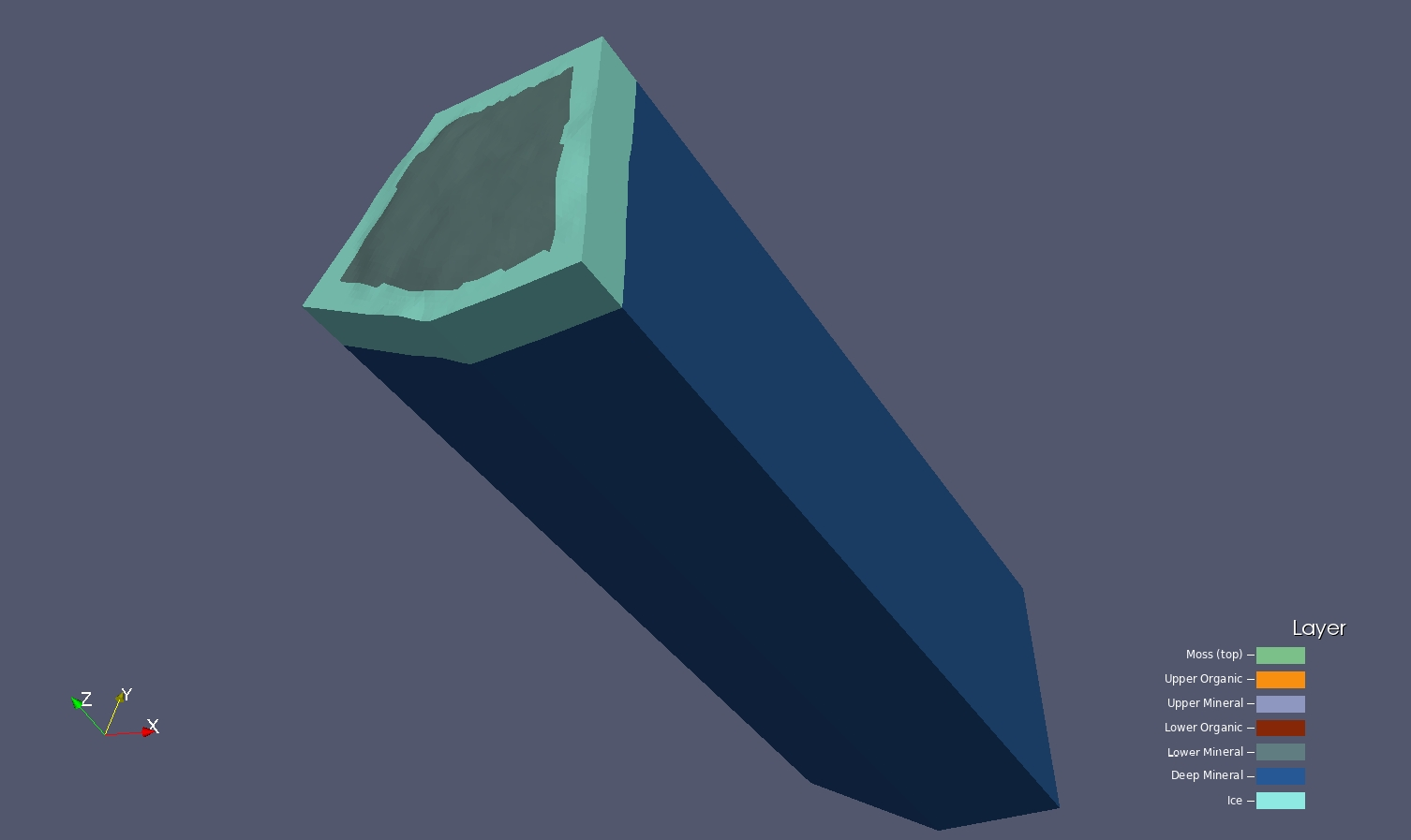
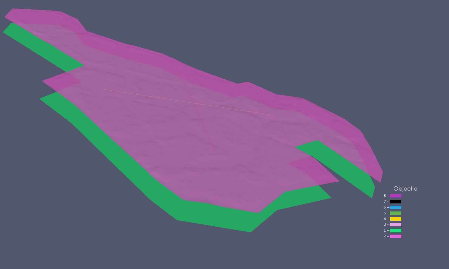
Full Stacked Mesh with Ice Wedge
6 material layers plus ice material
 |
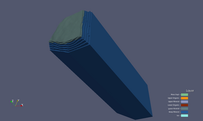
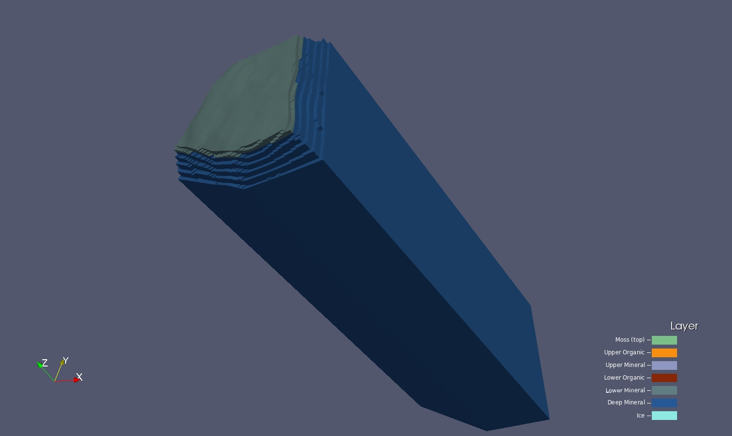
Full Stacked Mesh with Ice Wedge
with nonuniform mesh shown
 |
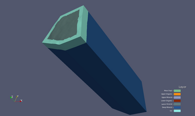
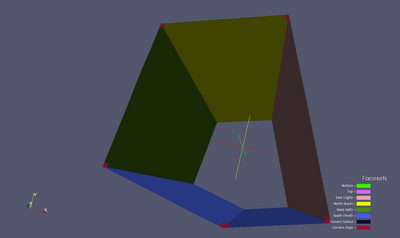
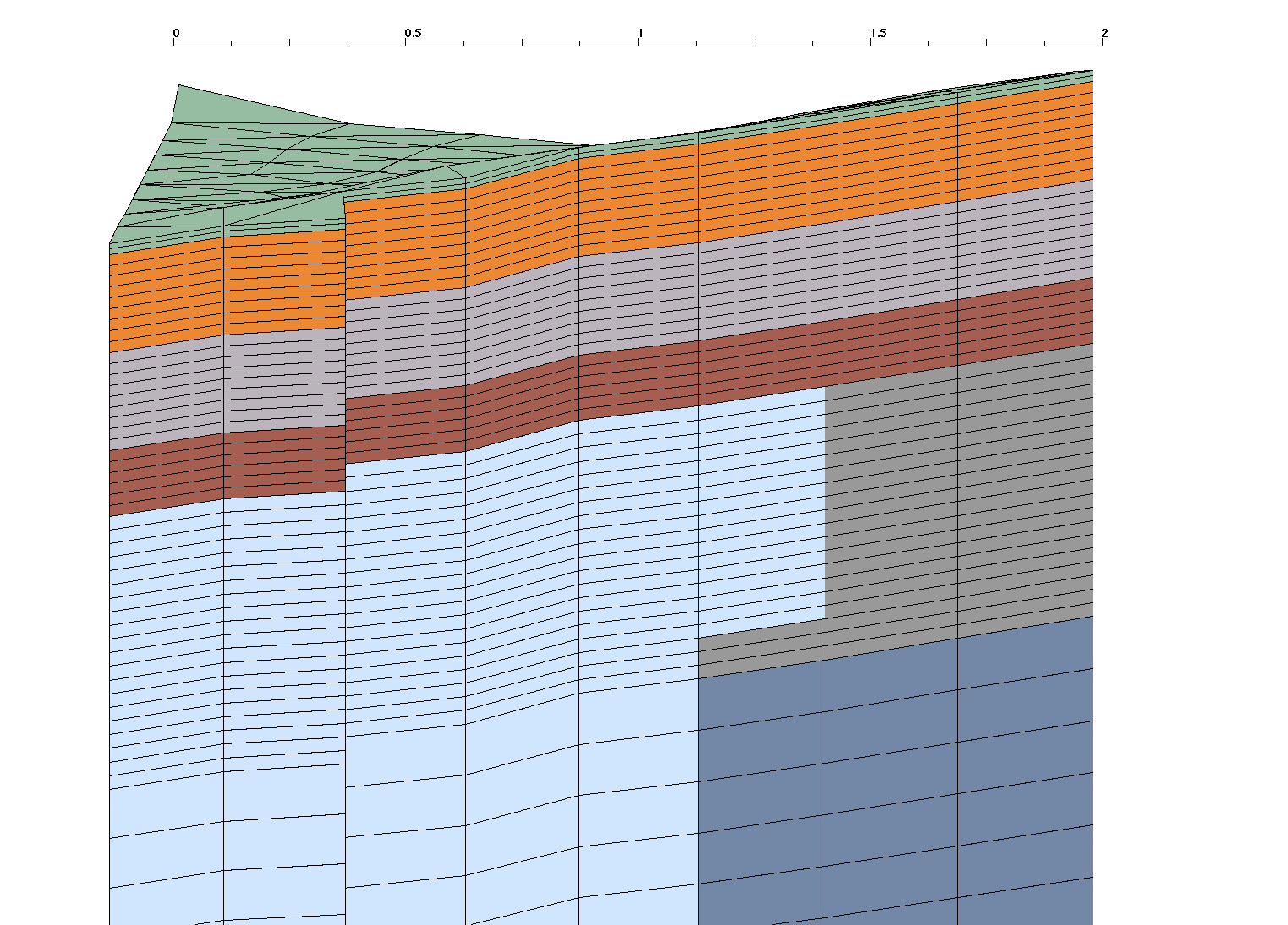
Mesh and Ice Wedge
with moss and organic layers removed
 |
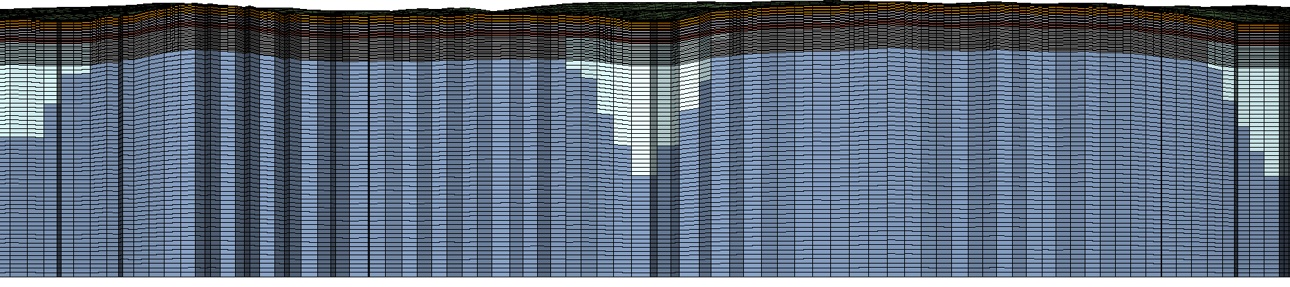
Mesh
with moss, organic, and ice layers removed
 |
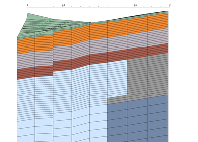
Mesh Input Parameters V3.2.C.1
General Description
Same as V03.C# for polygon #6. The only change was in the stack_full_poly.lgi file.This version uses the following layer definitions :
- Layer 1 (top) is the live organic layer and should be 2 cm thick with 2 cells.
- Organic layer such that all combined are 48 cm thick with 24 cells (2cm each).
- Top organic and mineral layer are the same. Thickness is 18 cm with 9 cells.
- Lowest organic layer is about 3/4 the thickness of upper 2 layers. Set thickness to 12 cm with 6 cells.
- The bottom Materials 5 and 6 are both mineral soils with higher resolution at the top of the mineral soil.
- The bottom material 6 has nonuniform mesh with higher resolution at the top.
- The domain bottom should be flat at Z = -45.
Material Ice Wedge
We want the top of the ice wedge to be at 50 cm depth (corresponds to the top of the inorganic layer).
Top of wedge starts at top of mineral layer (replaces cells only in materials 5 and 6)
Top wedge width (distance from polygon) is aprox 1.2
Depth from top of ice to tip is aprox 2.8
Outside Boundaries (Exodus side sets)
The side sets defined are top, bottom, and sides (corresponding to the 4 sectors within 45 degrees of each direction).
Output Mesh Description
Output is a stacked prism mesh written as two Exodus files; a single material mesh and a multi-material Mesh with 7 materials (6 layers plus the Ice Wedge).
Files are written in formats; Exodus II (.exo), AVS (.inp), and GMV (.gmv)
Final Mesh files: mesh_fsets.exo, mesh_fsets.gmv, mesh_fsets.inp
Final Mesh with single material: mesh_fsets_1mat.exo, mesh_fsets_1mat.gmv, mesh_fsets_1mat.inp
Mesh Element Type:             prism
Mesh Software Used: LaGriT, ExodusII

Total nodes:          229284
Total elements:       435968
Total Volume:  0.1054700E+05

from file write_exo.out.txt:
Mesh Extents (Meters):
              MIN               MAX       DIFFERENCE
 x     1.178399963E+02  1.355899963E+02 1.775000000E+01
 y     4.647000122E+01  6.374094009E+01 1.727093887E+01
 z    -4.500000000E+01  4.837786675E+00 4.983778667E+01

from file write_exo.out.txt:
SUMMARY VOLUME/AREA METERS of ELEMENT COLORS (BLOCKS)
Color    Num. Elements   Volume          Fractional Volume
    1        6656          0.4250232E+01     0.000402980
    2       29952          0.3825209E+02     0.003626822
    3       29952          0.3825219E+02     0.003626832
    4       19968          0.2550139E+02     0.002417882
    5       43210          0.6873682E+02     0.006517193
    6      267896          0.1023834E+05     0.970735425
   30       38334          0.1336607E+03     0.012672866

from file stack_full_poly.out.txt:
SUMMARY ELEVATIONS at LAYER TOPS (METERS)
        MIN          MAX       DIFF MAX below (thickness)
  1   4.429399967   4.837786674   .02
  2   4.409399967   4.817786674   .18

  3   4.229399967   4.637786674   .18
  4   4.049399967   4.457786674   .12
  5   3.929399967   4.337786674   .50
  6 -15.57060003  -15.16221333  19.49
      (Bottom is flat at -45.0)
Mesh Layer Definitions (meters)
|
| ID |
Layer Name |
Layer
Thick |
Layer
Vertical Cells |
Layer
Volume |
Min Top
Elevation |
Max Top
Elevation |
| 1 |
moss(top) |
0.02 |
2 x .01 |
4.250232 |
4.50 |
4.99 |
| 2 |
upper organic |
0.18 |
9 x .02 |
38.25209 |
4.48 |
4.97 |
| 3 |
upper mineral |
0.18 |
9 x .02 |
38.25219 |
4.30 |
4.79 |
| 4 |
lower organic |
0.12 |
6 x .02 |
25.50139 |
4.12 |
4.61 |
| 5 |
lower mineral |
0.50 |
20 x .025 |
68.73682 |
4.00 |
4.49 |
| 6 |
deep mineral |
2.2 -
19.49 |
50 x 0.1
10 x 0.4
10 x 1
15 x 2
|
10238.34 |
3.50 |
3.99 |
| 7/30 |
ice |
0.00 -
2.3 |
variable |
133.6607 |
4.49 |
4.00 |
|  |
Boundary Side Sets
|
Top and Bottom:
neon-pink  top     (num_side_ss2) has  3328 faces
neon-green bottom  (num_side_ss1) has  3328 faces
|
Sides:
red     east right   (num_side_ss3) has  4192 faces
yellow  north back   (num_side_ss4) has  4192 faces
green   west left    (num_side_ss5) has  4192 faces
blue    south front  (num_side_ss6) has  6288 faces
|
 |
 |
Project Archive Location
Full Set of files:
/scratch/sft2/lucia/grid_gen/arctic/arctic_fine_deep_poly06/

tar files created (*tgz):
-rw-r--r--   1 lucia  sft    131893910 Mar  5 14:48 poly06_fine_deep.tgz

Created from clean subdirectories with mesh files:
drwxr-xr-x   3 lucia  sftus       8192 Jan  7 16:35 poly06_fine_deep

LaGriT faceset files with elem number and face (*.faceset):
-rw-r--r--  1 lucia  sft  43367 Nov  6 10:34 fs_1_bot.faceset
-rw-r--r--  1 lucia  sft  36711 Nov  6 10:34 fs_2_top.faceset
-rw-r--r--  1 lucia  sft  58791 Nov  6 10:34 fs_3_rig.faceset
-rw-r--r--  1 lucia  sft  58791 Nov  6 10:34 fs_4_bac.faceset
-rw-r--r--  1 lucia  sft  58791 Nov  6 10:34 fs_5_lef.faceset
-rw-r--r--  1 lucia  sft  88135 Nov  6 10:34 fs_6_fro.faceset
-rw-r--r--  1 lucia  sft    223 Nov  6 10:34 fs_7_Csides.faceset
-rw-r--r--  1 lucia  sft    224 Nov  6 10:34 fs_8_Ctop.faceset

Mesh and faceset files for 6 Materials (mesh_fsets.*):
-rw-r--r--  1 lucia  sft  19662912 Nov  6 10:34 mesh_fsets.exo
-rw-r--r--  1 lucia  sft  33565104 Nov  6 10:34 mesh_fsets.gmv
-rw-r--r--  1 lucia  sft  65191636 Nov  6 10:34 mesh_fsets.inp

Mesh and faceset files for 1 Material (mesh_fsets_1mat.*):
-rw-r--r--  1 lucia  sft  19660940 Nov  6 10:34 mesh_fsets_1mat.exo
-rw-r--r--  1 lucia  sft  31447368 Nov  6 10:34 mesh_fsets_1mat.gmv
-rw-r--r--  1 lucia  sft  64962352 Nov  6 10:34 mesh_fsets_1mat.inp

LaGriT output files contain information reported during the run (*.out.txt):
-rw-r--r--  1 lucia  sft    4963 Nov  6 10:33 get_boundary_pts.out.txt
-rw-r--r--  1 lucia  sft    4799 Nov  6 10:33 get_poly_surf.out.txt
-rw-r--r--  1 lucia  sft   11698 Nov  6 10:32 interpolate.out.txt
-rw-r--r--  1 lucia  sft   20419 Nov  6 10:34 interpolate_icewedge.out.txt
-rw-r--r--  1 lucia  sft  105831 Nov  6 10:33 make_poly10006.out.txt
-rw-r--r--  1 lucia  sft    5781 Nov  6 10:33 merge_ice.out.txt
-rw-r--r--  1 lucia  sft  302436 Nov  6 10:33 merge_polys.out.txt
-rw-r--r--  1 lucia  sft    5546 Nov  6 10:33 process_lidar.out.txt
-rw-r--r--  1 lucia  sft  550714 Nov  6 10:33 refine.out.txt
-rw-r--r--  1 lucia  sft    3748 Nov  6 10:33 set_zeroz.out.txt
-rw-r--r--  1 lucia  sft  364447 Nov  6 10:33 stack_full_poly.out.txt
-rw-r--r--  1 lucia  sft       0 Mar  5 12:33 stack_full_poly2.out.txt
-rw-r--r--  1 lucia  sft  105639 Nov  6 10:34 write_exo.out.txt

Mesh images:
/scratch/sft2/lucia/grid_gen/arctic/arctic_fine_deep_poly06/images
Input Data files:
/scratch/sft2/lucia/grid_gen/arctic/arctic_fine_v3_C_1/input

-rw-r--r--  2 lucia  sftus  30928912 Jul  9 11:47 lidar_site3.inp
-rw-r--r--  1 lucia  sftus       123 Jul  9 11:47 poly10001.avs
-rw-r--r--  1 lucia  sftus       178 Jul  9 11:47 poly10002.avs
						...
-rw-r--r--  1 lucia  sftus       155 Jul  9 11:47 poly10071.avs
-rw-r--r--  1 lucia  sftus       190 Jul  9 11:47 poly10072.avs
Main Work Directory for Polygon Meshing Method:
/scratch/sft2/lucia/grid_gen/arctic/
Links to Images and Project Details
Gallery of All Project Images
Method Description Overview (from V01)
Input and Output Files Running LaGriT to create the Mesh
These are LaGriT input (.lgi) and output (outx3dgen) files used in creating this mesh. The output files provide good information about the data and mesh, including min and max values of mesh attributes.
The complete set of scripts and input files are in /scratch/sft2/lucia/grid_gen/arctic/arctic_fine_deep_poly06. The output files for various mesh versions are in /home/lucia/sandbox/arctic and /scratch/sft2/lucia/grid_gen/arctic/.
Steps to create the surface mesh for all polygons
To create a surface mesh, we run 2 python scripts. Normally, the Path 1 doesn't need to be re-run, so we just copy output files from this run to the output folder from the folder output_surf_mesh. If any of the Part 1 scripts are changed, then the Part 1 should be re-run, so Path 1 or 2 should be taken.
Path 1: Run script surf_mesh.py.
Path 2: (If you didn't run Part 1, remove all the files from the ouput folder. Then copy files from directory output_surf_mesh into the output folder.) Run script mesh_adjoin.py
Steps to create the 3D mesh for several polygons
The easiest path is to run surf_mesh.py and then mesh_adjoin.py scripts. That creates necessary LaGriT files and runs other scripts.
Step 1: Create Ice Objects from Polygon make_poly.lgi. This script is used to create all polygons separately. The Input is the same for all polygons. The output is different for all the polygons, but it is similar. To get the output for the polygon you are interested in, change the # of the polygon in the link: make_poly<enter_your_number>.out.txt
- Polygon #6: Output
Step 2: Merge all the ice objects created in Step 1. Input Output
Step 3: Create and stack layers into full mesh (stack_full_poly.lgi) Input Output
Step 4: Interpolate Ice Material on to Full Stacked Mesh (interpolate_icewedge.lgi) Input Output
Step 5: Create facesets and write final Exodus files (write_exo.lgi) Input Output
Grid Team Contacts
| Carl Gable |
<gable -at- lanl -dot- gov> |
505-665-3533 |
| Terry Miller |
<tamiller -at- lanl -dot- gov> |
505-667-8009 |
| Lucia Short |
<lucia -at- lanl -dot- gov> |
505-665-7957 |
