Grid Project: Arctic Fine Mesh for Areas A and B
| Grid Team Member: |
Terry Miller |
| Data Source: |
EES-14 LiDAR and Polygons for Barrow |
| Delivered To: |
Ethan Coon, Scott Painter |
| Date: |
November 2016 to present |
Version History
| Version |
Scope |
Finished |
Total |
| Fine Deep Mesh |
| V4.2.0_A.5 |
Area A Poly 5, Ice 4.5m |
Dec 2017 |
983,155 Nodes and |
1,913,600 Cells |
| V4.2.0_A.5 |
Area A Poly 5, Ice 1.4m |
Dec 2017 |
983,155 Nodes and |
1,913,600 Cells |
| V4.2.0_A.2 |
Area A Poly 2, Ice 4.5m |
Dec 2017 |
1,429,603 Nodes and |
2,795,520 Cells |
| V4.2.0_A.2 |
Area A Poly 2, Ice 1.4m |
Dec 2017 |
1,429,603 Nodes and |
2,795,520 Cells |
| V4.2.0_A.1 |
Area A Poly 1, Ice 4.5m |
Dec 2017 |
381,603 Nodes and |
732,160 Cells |
| V4.2.0_A.1 |
Area A Poly 1, Ice 1.4m |
Jan 2017 |
381,603 Nodes and |
732,160 Cells |
| V4.2.0_B.1 |
Area B Poly 1, Ice 1.4m |
Nov 2016 |
413,043 Nodes and |
798,720 Cells |
| Fine Mesh Previous Work |
| V1-V3 |
Area C Index |
2013-2014 |
|
|
Project Overview
These meshes were developed in support of the Arctic Next Generation Ecosystem Experiment (NGEE-Arctic) Project and LANL Laboratory Directed project LDRD20120068DR. These two projects share a need for high quality computational meshes for use in fine-scale modeling of thermal hydrology in ice-wedge polygon landscapes.
The conceptual design for these models are based on observations and data collected for the Arctic project. The top
surface uses elevation and image data of tundra areas A, B, and C.
The top surfaces of these models are polygonal tundra shapes and elevations derived from actual LiDAR data sets.
The subsurface layers of the models are based on descriptions and observations of core data. The layers represented are
moss (part of the active layer), organic, and mineral.
The ice wedge shape follows the tundra polygons and have a constant rim width and constant depth to pinched end point. The top of the ice wedge is below the permafrost boundary.
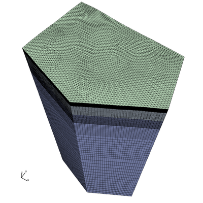
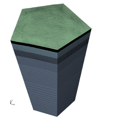
Mesh Versions 4.2 Fine Deep with 6 Layers plus Ice
These are single polygon meshes selected from Area A Low Center Polygons (LCP) and Area B High Center Polygons (HCP).
Parameters and workflow are based on V3.2.C.1 Area C fine deep mesh in
/scratch/sft2/lucia/grid_gen/arctic/arctic_fine_deep_poly06/
Modified so moss has 1 cell layer instead of 2 cells. The moss layer thickness remains .02 meters.
Modified for adjustment of ice width and slope.
Input Parameters
- Layer 1 (top) is moss and should be 2 cm thick.
- The organic layers combined are 48 cm thick.
- Top organic and mineral layer are the same with thickness of 18 cm.
- Lowest organic layer is about 3/4 the thickness of upper 2 layers. Set thickness to 12 cm.
- The bottom Materials 5 and 6 are both mineral soils with higher resolution at the top of the mineral soil.
- The bottom material 6 has variable thickness with higher resolution layers at the top.
- The domain bottom should be flat at Z = -45.
- The top of the ice wedge should be at 50 cm depth (corresponds to the top of the inorganic layer).
- Top of wedge starts at top of mineral layer (replaces cells only in materials 5 and 6)
- Depth from top of ice to tip is aprox 2.8
- Top ice wedge width (distance from polygon) is aprox 1.4m or 4.5m
Stacked Layers
  ID  Name         Mat Thickness  Num Cells
  1   moss             .02          1
  2   upper organic    .18          9
  3   upper mineral    .18          9
  4   lower organic    .12          6
  5   lower mineral    .50         20
  6   deep mineral     ~49         85
  7   ice              ~2.8        --
Mesh Archives
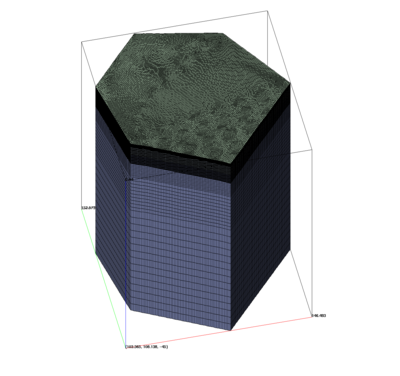
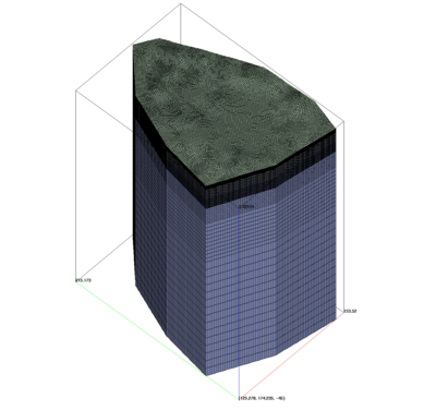
  AREA B LiDAR with High Center Polygon #1
  Nodes:  413043
  Cells:  798720

  The elevation data for this mesh was corrected to cell centers.
  The result is a slight correction of the polygon relative to elevations.

      MIN       MAX       LENGTH (meters)
   x  102.551   127.760   25.2087
   y   84.975   109.696   24.7216
   z  -45.000     5.441   50.4413

   REPLACED DATA (from Nov 2016)
   x  102.300   127.510   25.2087
   y   84.975   109.696   24.7216
   z  -45.000     5.449   50.4486

  Links:
    Mesh Details
    Mesh Gallery of Images
    Input LiDAR and Polygon Data
    Method for this Mesh
    File README.txt


  Download ExodusII Mesh Only:  mesh_areab_poly01_v04.2.B.1.tgz (9.2M)
    Files: mesh_fs.exo README.txt

  Download Full Archive:  archive_areab_poly01_v04.2.B.1.tgz (63M)
    Files: mesh_fs.exo .inp .gmv README.txt mesh.html method.html
    Folders: /images /lagrit_input_files /lagrit_output_files

  Local:
    /scratch/sft/tam/grid_gen/arctic/areab_fine_deep/areab_fine_deep_poly01
|
Grid Team Contacts
| Carl Gable |
<gable -at- lanl -dot- gov> |
505-665-3533 |
| Terry Miller |
<tamiller -at- lanl -dot- gov> |
505-667-8009 |