Grid Project: Arctic Intermediate Scale
| Grid Team Member: |
Terry Miller |
| Version: |
Intermediate scale |
| Data Source: |
LiDAR and polygon data from Chandana and Arctic
program |
| Delivered To: |
Scott Painter, Rao Garimella, Ethan Coon |
| Date: |
December 2013 to present |
Version History
| Version |
Scope |
Finished |
Nodes |
Cells |
| Proto Full 2 |
Lobster Prism with convex
polygons |
pending |
|
|
| Proto Full |
Lobster Prism with Phedra
numbers |
Sep 22 2015 |
59,532 |
113,184 |
| Proto 2Poly |
Proto Prism of 2 Polys, 3
materials |
Sep 20 2015 |
270 |
396 |
| V03.2 |
Lobster Quad to 4 Tri Tall |
Jan 10 2014 |
59,532 |
113,184 |
| V03.1 |
Lobster Quad to 4 Tri |
Jan 10 2014 |
43,747 |
82,944 |
| V02.2 |
Lobster Quads Tall |
Jan 10 2014 |
34,188 |
37,859 |
| V02.1 |
Lobster Quads Fixed |
Jan 10 2014 |
25,123 |
27,744 |
| V01 |
Lobster Quads Proto |
Jan 7 2014 |
25,414 |
28,608 |
Project Overview
This project is for Arctic Intermediate Scale Modeling. These meshes are
developed based on work for fine-scale modeling of thermal hydrology in
ice-wedge polygon landscapes. The conceptual design for these models are
the same as the fine-scale models and are based on observations and data
collected for the Arctic project.
The top surfaces of these models are polygonal tundra shapes and
elevations derived from LIDAR data sets.
Each polygon is processed with offsets calculated to represent the
half-trough, rim, and center. Each poly ring is converted to quad cells
with thickness equal to the defined offsets. The center is filled with
cell edges at rim and connecting to a center point. Polygon cells are
merged to create a top surface layer. The surface elevations are
interpolated from the Lidar data on to each cell vertice point.
The subsurface layers are derived from the top surface to selected depths.
These surfaces are stacked and filled with cell volumes with thickness
defined by the stacked layers. The layer thickness for each material are
based on descriptions and observations of core data. The material layers
represented are
moss (part of the active layer)
upper and lower organic
upper, lower, and deep mineral
The methods and data used for these intermediate-scale meshes were
developed during design and meshing for the Arctic Fine-scale work. See
fine-scale project pages at meshing.lanl.gov/proj/arctic_ice_wedge_poly/index.html
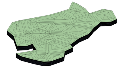
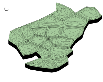
Polyhedral Meshing
These start with the Arctic polygon meshes used for modeling, but
explore stategies to represent the meshes as column cells with unique
polyhedral id's. Rao Garimella using a prototype code to coalesce elements
of a particular type (material ID, same polyhedral ID, etc) to create
Intermediate scale polygonal meshes for modeling.
Images
of Polyhedral Mesh Prototypes
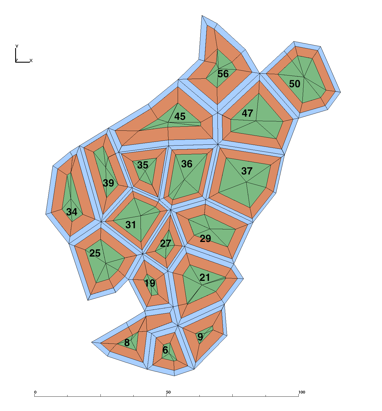
Prototype Lobster Prism with convex Polygons, no rings
The concave polygons ## 8, 45, and 56 got divided each into 2 polygons
such that polygon #8 became ## 8 and 74, #45 => ## 45 and 75, #56 =>
#56 and 76.
Subset Lobster with 4 convex polygons: ## 8, 74, 6, 9
Local: /scratch/sft2/lucia/grid_gen/arctic/lobster/subset01

  Download Archive lobster_convex_proto01.tar.gz    ( 0.18 M )
Prototype Lobster Prism with Polyhedral Id's
Proto Lobster prism mesh, tall version 3.2
number of nodes:                 59532
number of elements:             113184

Mesh attributes:
  poly_id   are the polygons with Arctic polygon id 1-56
  layer_id  are the single cell layers from bottom to top starting at 0
  phedra_id = poly_id(6 to 56) x num_layers(fixed) + layer_id(0 to n)

  Files include:
  GMV binary and ascii, AVS, ExodusII (no attributes)
  .txt attribute arrays, .dat adjacency jtet arrays.
  *lgi lagrit input files to create the mesh from tri poly surface

Full Lobster with all polygons:

Local: /scratch/sft/tam/grid_gen/arctic/intermediate_scale/mesh_hex_lobster/stack_quadtotri4_tall/polyhedral_files

  Download Archive lobster_phedra_prism_tall.tar.gz    ( 11 M )

Subset Lobster with 2 polygons:

Local: /scratch/sft/tam/grid_gen/arctic/intermediate_scale/mesh_hex_lobster/stack_quadtotri4_tall/polyhedral_files/subset_2poly

  Download Archive lobster_phedra_2poly.tar.gz    ( 1.9 M )
Prototype Prism with 2 Polygons
Proto prism with 2 polygons, quad elements converted to 4 triangles each.
There are 3 materials and 4 layers.
number of nodes:                 270
number of elements:              396

  matclr      is material id (same as GMV itetclr)
  ring_id     for each polygon, 3 = outer edge, 2 = rim middle, 1 = center
  num_layers  are the total number of layers
  poly_id     are the polygons with Arctic polygon 1-56 (may have to sub 10000)
  layer_id    are the single cell layers from bottom to top starting at 0
  phedra_id   = poly_id(6 to 56) x num_layers(fixed) + layer_id(0 to n)

  Files include:
  GMV binary and ascii, AVS, ExodusII (no attributes)
  .txt attribute arrays, .dat adjacency jtet arrays.

Local: /scratch/sft/tam/grid_gen/arctic/intermediate_scale/proto_polyhedral/tri_to_prism_v2/output_files

  Download Archive proto_phedra_prism.tar.gz    ( 411 K )
Proto Mesh types that did not work:
Proto hex with 2 polygons, quad elements converted so shared center have duplicate nodes
This enables the quad and hex elements to have a unique node index rather than repeating.
Local: /scratch/sft/tam/grid_gen/arctic/intermediate_scale/proto_polyhedral/quad2_to_hex/output_files

Proto Hex 1 with Single Node at degen center.
The hex indices have repeated numbers rather than unique numbers from duplicate nodes.
Local: /scratch/sft/tam/grid_gen/arctic/intermediate_scale/proto_polyhedral/quad1_to_hex/output_files
Lobster Mesh and Output Files
Files are available on local servers or you can download the compressed
".tar.gz" archive. See mesh details and locations below.
Mesh Overview and
Images
View Gallery
of All Mesh Images
Local: /scratch/sft/tam/grid_gen/arctic/intermediate_scale/mesh_hex_lobster/images
Polygon Overview
and Images
View Gallery of
All Polygon Images
Local: /scratch/sft/tam/grid_gen/arctic/intermediate_scale/polys_intermediate/images
| V2 Mesh (Lobster Quads Stacked
into Hex) : 259 nodes and 289 quad cells per layer |
 |
This mesh starts with polygons converted to quad cells the same
thickness as the polygon offsets. The center polygon is made up of
degenerate quad cells which converge at a center point. This
strategy has the fewest number of cells and nodes. Two sets of mesh
files are written (multi-material and single) in formats: AVS, GMV,
and Exodus II.
V2.1 Hex Mesh:
/scratch/sft/tam/grid_gen/arctic/intermediate_scale/mesh_hex_lobster/stack_quad_rmslivers
Download Archive
V02.1_stack_quad.tar.gz ( 6.2 MB )
V2.2 Tall Hex Mesh:
/scratch/sft/tam/grid_gen/arctic/intermediate_scale/mesh_hex_lobster/stack_quad_rmsl_tall
Download
Archive V02.2_stack_quad_tall.tar.gz ( 7.6 MB )
|
| V3 Mesh (Lobster Triangles Stacked
into Prism) : 451 nodes and 864 triangle cells per layer |
 |
This mesh starts with polygons converted to quad cells the same
thickness as the polygon offsets. Each quad cell is converted to 4
triangles with added center point. The degenerate quad cells making
up the center piece are converted to triangles sharing a vertice at
the center point. Two sets of mesh files are written (multi-material
and single) in formats: AVS, GMV, and Exodus II.
V3.1 Prism Mesh:
/scratch/sft/tam/grid_gen/arctic/intermediate_scale/mesh_hex_lobster/stack_quadtotri4
Download Archive
V03.1_stack_tri.tar.gz ( 14 MB )
V3.2 Tall Hex Mesh:
/scratch/sft/tam/grid_gen/arctic/intermediate_scale/mesh_hex_lobster/stack_quadtotri4_tall
Download Archive
V03.2_stack_tri_tall.tar.gz ( 17 MB )
|
The following definitions apply to all the meshes:

Polygons from Site C called extended lobster (adds 56):
1  2  3  4   5   6   7   8   9   10  11  12  13  14  15  16  17  18
6, 8, 9, 19, 21, 25, 27, 29, 31, 34, 35, 36, 37, 39, 45, 47, 50, 56

Materials for all grids:
1 Moss (top)
2 Upper Organic
3 Upper Mineral
4 Lower Organic
5 Lower Mineral
6 Deep Mineral

Boundary Side Sets (Facesets) for all grids:
Top     (num_side_ss2)
Bottom  (num_side_ss1)
Side east right   (num_side_ss3)
Side north back   (num_side_ss4)
Side west left    (num_side_ss5)
Side south front  (num_side_ss6)

Mesh Vertical Layers for all:
1       top at Lidar elevations
1       .02 Thick       2  cells x .01
2       .18 Thick       9  cells x .02
3       .18 Thick       9  cells x .02
4       .12 Thick       6  cells x .02
5       .50 Thick       20 cells x .025

Bottom layers for short:
6       variable thickness with 50 cells near .09
6       bottom at -1.

Bottom layers for tall:
6       5.  Thick       50 cells x  .1
6       4.  Thick       10 cells x  .4
6       10. Thick       10 cells x 1.0
6       variable thickness with 15 cells near 1.9
6       bottom at -45.

Exodus Facesets:
1 Bottom  (num_side_ss1)
2 Top     (num_side_ss2)
3 Side east right   (num_side_ss3)
4 Side north back   (num_side_ss4)
5 Side west left    (num_side_ss5)
6 Side south front  (num_side_ss6)

Mesh information can be found in mesh directory in README.txt, RUNS, *.out
Mesh Files are written in formats; Exodus II (.exo), AVS (.inp), and GMV (.gmv)
Final Top surface for deriving layers: poly_top_surf.inp poly_top_surf.gmv
Final Mesh with multi-materials: mesh_fsets.exo, mesh_fsets.gmv, mesh_fsets.inp
Final Mesh with single material: mesh_fsets_1mat.exo, mesh_fsets_1mat.gmv, mesh_fsets_1mat.inp
Input Data
Area C Polygons and Elevations
The input data is organized into a set of files that contain data
extracted from lidar
data. The data set is canonized by Chandana
Gangodagamage and organized into a set of input files. These
input files include ground surface elevations, polygon shape coordinates,
and widths for rims and troughs. Thank you to Craig Tweedie, University of
Texas, El Paso, for providing the Lidar data for use in these projects.
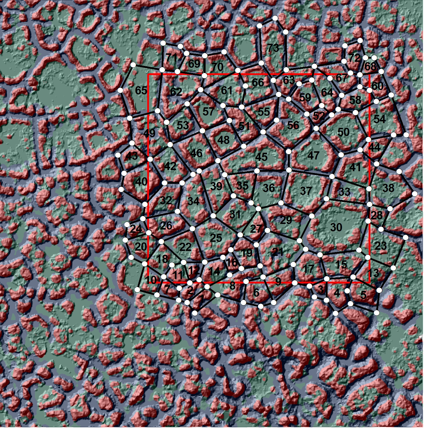
NGEE extensive site-C Lidar Elevations with Polygon Id's
ASCII AVS file with elevation for each x,y location:
/scratch/sft/tam/grid_gen/arctic/intermediate_scale/input_poly_data/lidar_site3.inp
|

Lobster Polygons as Quad Cells with Polygon Id's
ASCII AVS file with half-trough and rim widths for each polygon:
/scratch/sft/tam/grid_gen/arctic/intermediate_scale/input_poly_data/polygon_areaC_trough_halfwidths_rims_final72.csv
|
Methods
Input Data Processing Prepare elevation data and polygon offset
data:
/scratch/sft/tam/grid_gen/arctic/intermediate_scale/ input_poly_data/README.txt
Polygon Processing Create offsets and connect into poly surface:
/scratch/sft/tam/grid_gen/arctic/intermediate_scale/ polys_intermediate/RUNS
Mesh Generation Stack poly surface into layered volumes:
/scratch/sft/tam/grid_gen/arctic/intermediate_scale/ mesh_hex_lobster/Methods.txt
Grid Team Contacts
| Carl Gable |
<gable -at- lanl -dot- gov> |
505-665-3533 |
| Terry Miller |
<tamiller -at- lanl -dot- gov> |
505-667-8009 |
| Lucia Short |
<lucia -at- lanl -dot- gov> |
505-665-7957 |