Grid Project: Wyoming CO2 MOXA Brick Mesh
| Grid Team Member: |
Terry Miller |
| Grid Versions: |
Version 01 Brick Mesh (for scoping) |
| Data Source: |
EV La Barge Model seis3d from John Jiao, WSGS |
| Delivered To: |
Phil Stauffer |
| Date Completed: |
2/22/2011 |
Grid Project: Wyoming CO2 MOXA Upscale Mesh
See also, Version 02 Stacked Mesh with upscaled perm and por values.
Project Despcription page and gallery.
Purpose of Project
This is a coarse mesh prototype to setup modeling for the por and perm modeling.
The vertical spacing is 32 meters, too coarse to use for the porosity and permability upscale values. This version will represent the geology and the injection well. The Version 02 mesh will include the por and perm values.
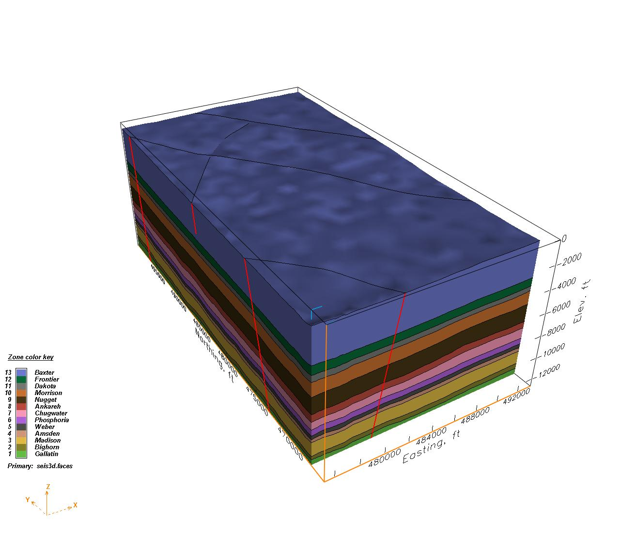
EV La Barge Zone Materials
|
Brick Mesh Zone Materials
|
Generate a scoping mesh for the 3-D model (from La Barge 3-D seismic data) sent by John Jiao, WSGS
. The mesh will represent an injection well in the middle of the survey to evaluate how much CO2 could be
injected to Weber Sandstone and Madison Limestone.
The well location is at X 482800 ft and Y 476300 ft. The target interval Weber Sandstone
at the well location for CO2 injection ranges from -10600 to -11800 ft (elevation) or dept
h 11300 to 18500 ft in depth.
The Wyoming EV model consists of La Barge structural, porosity, and permeability models.
Three faces files are included, seis3d.faces for structure, por.por.faces for porosity, an
d perm_Vernik_perm.faces for permeability.
For scoping we may use 100 ft gridding size at the near injection location and then gradually coarsening away from the well.
Design Issues:
Can the mesh be unstructured? A stacked mesh with conforming voronoi at material interfaces will allow horizontal movement.
What is the interval and resolution for the injection well?
Madison and Weber are the target material zones. What resolution is needed for these materials? What about adjoining materials? Can the mesh size be reduced by reducing the number of materials represented? Put top betwen Nugget and Frontier?
Is the well vertical? Should the well be represented in the mesh from injection interval to the surface of the mesh?
How will the Porosity and Permeability model values be used in the modeling process? Will the values be used as mesh node attributes, or some type of input into the FEHM codes?
What is the resolution of the EV porosity and permeability models? What resolution of the mesh is needed to capture this?
What type of upscale method should be used for perm and por? Should LaGriT upscale methods be used? Something outside of LaGriT?
Project Images
Gallery of All Images
Project Summary
| Dimension: |
3D |
| Grid Element Type: |
Tetrahedral |
| Grid Software Used: |
EV and LaGriT |
| |
| |
Brick Mesh |
Stacked Mesh |
| Number of Nodes: |
97156 |
(in development) |
| Number of Elements: |
540932 |
(in development) |
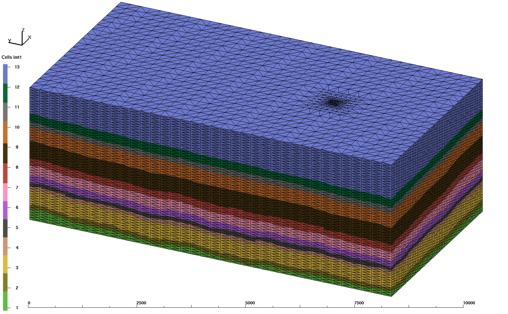
Brick Mesh Description
This is a straight forward design intended as a scoping mesh for modeling efforts. It has vertical spacing of 32 meters within a rectangle brick shape. Horizontal spacing is 256 x 256 meters which is refined by halves near the well such that spacing along the full vertical x,y location is 32x32x32 meters. The edges along the material interfaces are therefor stair-stepped and will inhibit horizontal flow somewhat, but will be adequate for the intended scoping runs.
Target resolution for the stacked mesh will depend on scoping results and the resolution needed to capture details from the Permeability and Porosity EV models. Refinement will be needed at well injection area and along the target materials and their interfaces.
Upscaling scenarios will need to be explored so the mesh can best take advantage of the methods to be used.
Brick Mesh Zone Materials
|
Baxter       13 has     21425 nodes. #nodes/nnodes is   0.2205
Frontier     12 has      6347 nodes. #nodes/nnodes is   0.0653
Dakota       11 has      3804 nodes. #nodes/nnodes is   0.0391
Morrison     10 has      9940 nodes. #nodes/nnodes is   0.1020
Nugget        9 has     12344 nodes. #nodes/nnodes is   0.1270
Ankareh       8 has      5329 nodes. #nodes/nnodes is   0.0548
Chugwater     7 has      6997 nodes. #nodes/nnodes is   0.0720
Phosphoria    6 has      4695 nodes. #nodes/nnodes is   0.0483
Weber         5 has      3180 nodes. #nodes/nnodes is   0.0327
Amsden        4 has      3051 nodes. #nodes/nnodes is   0.0314
Madison       3 has     10764 nodes. #nodes/nnodes is   0.1107
Bighorn       2 has      4026 nodes. #nodes/nnodes is   0.0414
Gallatin      1 has      5254 nodes. #nodes/nnodes is   0.0540
Excerpts from README file.
First pass brick mesh with horizontal refinement at well location.
The point count is     97156.
The element count is  540932.

Background mesh with 256x256x32 meter spacing
Refined 3 levels horizontaly along x,y location of well
So resolution at well location is 32x32x32

                 MIN               MAX         DIFFERENCE     NODES
METERS
 xic     1.448530000E+05  1.497170000E+05 4.864000000E+03     97156
 yic     1.426160000E+05  1.518320000E+05 9.216000000E+03     97156
 zic    -3.840000000E+03 -4.480000000E+02 3.392000000E+03     97156

FEET
 xic     4.752395013E+05  4.911975066E+05 1.595800525E+04     97156
 yic     4.679002625E+05  4.981364829E+05 3.023622047E+04     97156
 zic    -1.259842520E+04 -1.469816273E+03 1.112860892E+04     97156


Material Nodes

Baxter       13 has     21425 nodes. #nodes/nnodes is   0.220521628857
Frontier     12 has      6347 nodes. #nodes/nnodes is   0.653279274702E-01
Dakota       11 has      3804 nodes. #nodes/nnodes is   0.391535274684E-01
Morrison     10 has      9940 nodes. #nodes/nnodes is   0.102309688926
Nugget        9 has     12344 nodes. #nodes/nnodes is   0.127053394914
Ankareh       8 has      5329 nodes. #nodes/nnodes is   0.548499338329E-01
Chugwater     7 has      6997 nodes. #nodes/nnodes is   0.720181986690E-01
Phosphoria    6 has      4695 nodes. #nodes/nnodes is   0.483243428171E-01
Weber         5 has      3180 nodes. #nodes/nnodes is   0.327308662236E-01
Amsden        4 has      3051 nodes. #nodes/nnodes is   0.314031057060E-01
Madison       3 has     10764 nodes. #nodes/nnodes is   0.110790893435
Bighorn       2 has      4026 nodes. #nodes/nnodes is   0.414385125041E-01
Gallatin      1 has      5254 nodes. #nodes/nnodes is   0.540779791772E-01

THE PSET  pxy at well location       HAS        107 POINTS
THE PSET  pinj at injection interval HAS         12 POINTS

tet_node_attributes.dat (where well xy is 50 and well interval is 51)
THE PSET  pxy at well location       HAS        107 POINTS
THE PSET  pinj at injection interval HAS         12 POINTS

# node, integer
# imt1, integer
# vorvol, real
# iwell, integer
# xcoord, real
# ycoord, real
# zcoord, real

awk '{if ($4 > 50) print }' tet_node_attributes.dat
...
    4650   2  0.327679999999E+05   50  0.147157000000E+06  0.145176000000E+06 -0.364800000000E+04
    5390   2  0.327679999997E+05   50  0.147157000000E+06  0.145176000000E+06 -0.361600000000E+04
    6130   2  0.327680000000E+05   51  0.147157000000E+06  0.145176000000E+06 -0.358400000000E+04
    6870   3  0.327680000000E+05   51  0.147157000000E+06  0.145176000000E+06 -0.355200000000E+04
    7610   3  0.327680000006E+05   51  0.147157000000E+06  0.145176000000E+06 -0.352000000000E+04
    8350   3  0.327679999987E+05   51  0.147157000000E+06  0.145176000000E+06 -0.348800000000E+04
    9090   3  0.327680000012E+05   51  0.147157000000E+06  0.145176000000E+06 -0.345600000000E+04
    9830   3  0.327680000013E+05   51  0.147157000000E+06  0.145176000000E+06 -0.342400000000E+04
   10570   3  0.327680000005E+05   51  0.147157000000E+06  0.145176000000E+06 -0.339200000000E+04
   11310   3  0.327679999987E+05   51  0.147157000000E+06  0.145176000000E+06 -0.336000000000E+04
   12050   3  0.327680000022E+05   51  0.147157000000E+06  0.145176000000E+06 -0.332800000000E+04
   12790   3  0.327680000000E+05   51  0.147157000000E+06  0.145176000000E+06 -0.329600000000E+04
   13530   3  0.327679999990E+05   51  0.147157000000E+06  0.145176000000E+06 -0.326400000000E+04
   14270   3  0.327680000000E+05   51  0.147157000000E+06  0.145176000000E+06 -0.323200000000E+04
   15010   3  0.327679999953E+05   50  0.147157000000E+06  0.145176000000E+06 -0.320000000000E+04
   15750   4  0.327679999988E+05   50  0.147157000000E+06  0.145176000000E+06 -0.316800000000E+04
...

FEHM files:
-rw-r--r-- 1 tam pf 29076342 Feb 22 11:44 tet.fehmn
-rw-r--r-- 1 tam pf 18838609 Feb 22 11:45 tet.stor
-rw-r--r-- 1 tam pf  1069157 Feb 22 11:44 tet_material.zone
-rw-r--r-- 1 tam pf  1697350 Feb 22 11:44 tet_multi_mat.zone
-rw-r--r-- 1 tam pf   154411 Feb 22 11:44 tet_outside.zone
-rw-r--r-- 1 tam pf   890543 Feb 22 11:44 tet_outside_vor.area


Face top           1 has       908 nodes.
top        Sum Voronoi      Area_x          Area_y          Area_z
                       0.2949120E+06   0.1556480E+06   0.4482662E+08
Face bottom        2 has       908 nodes.
bottom     Sum Voronoi      Area_x          Area_y          Area_z
                       0.2949120E+06   0.1556480E+06   0.4482662E+08
Face left_w        3 has      3959 nodes.
left_w     Sum Voronoi      Area_x          Area_y          Area_z
                       0.3126067E+08   0.8683520E+06   0.2359296E+07
Face right_e       5 has      3959 nodes.
right_e    Sum Voronoi      Area_x          Area_y          Area_z
                       0.3126067E+08   0.8683520E+06   0.2359296E+07
Face back_n        6 has      2140 nodes.
back_n     Sum Voronoi      Area_x          Area_y          Area_z
                       0.8683520E+06   0.1649869E+08   0.1245184E+07
Face front_s       4 has      2140 nodes.
front_s    Sum Voronoi      Area_x          Area_y          Area_z
                       0.8683520E+06   0.1649869E+08   0.1245184E+07

*** Construct and Compress Sparse Matrix:3D ***
   *** Compress Area Coefficient Values ***
AMatbld3d_stor: *****Zero Negative Coefficients ******
AMatbld3d_stor: Number of 'zero' (< 10e-8*max) coefs       0
AMatbld3d_stor: npoints =    97156  n connections =     681486
AMatbld3d_stor: Number of written coefs =        28
AMatbld3d_stor: Maximum num. connections to a node =          9
AMatbld3d_stor: Volume min =   1.6384000E+04
AMatbld3d_stor: Volume max =   2.0971520E+06
AMatbld3d_stor: Total Volume:   1.5205191E+11
AMatbld3d_stor: abs(Aij/xij) min =   0.0000000E+00
AMatbld3d_stor: abs(Aij/xij) max =   2.0480000E+03
AMatbld3d_stor: (Aij/xij) max =   0.0000000E+00
AMatbld3d_stor: (Aij/xij) min =  -2.0480000E+03
Compression used for graph and coefficient values
The area coefficient values were written as scalar area/distance
ascii STOR file written with name tet.stor
Project Archive Location
Earthvision Models for Mesh Setup:
/scratch/fwo/wyo_ev_models/LaBarge1
  Geologic Material Zones: seis3d.seq
  Porosity Model: por.seq
  Permeability Model: perm_Vernik.seq
FEHMN files for brick mesh:
/scratch/fwo/tam/wy_2011/grid_brick
-rw-r--r-- 1 tam pf 29076342 Feb 22 11:44 tet.fehmn
-rw-r--r-- 1 tam pf 18838609 Feb 22 11:45 tet.stor

-rw-r--r-- 1 tam pf  1069157 Feb 22 11:44 tet_material.zone
-rw-r--r-- 1 tam pf  1697350 Feb 22 11:44 tet_multi_mat.zone
-rw-r--r-- 1 tam pf   154411 Feb 22 11:44 tet_outside.zone
-rw-r--r-- 1 tam pf   890543 Feb 22 11:44 tet_outside_vor.area

-rw-r--r-- 1 tam pf  9521403 Feb 25 13:00 tet_node_attributes.dat

-rw-r--r-- 1 tam pf 36694069 Feb 22 11:44 tet_connect.inp
-rw-r--r-- 1 tam pf 22372448 Feb 22 11:44 tet_connect.gmv
-rw-r--r-- 1 tam pf 29102771 Feb 22 11:44 tet_grid.plt
Project Details for Version 1 Brick Mesh
The Brick Mesh was created using LaGriT input files and Earthvision on the command line to query material zone values for the mesh point locations.
The steps to create this simple mesh were as follows:
In work directory /scratch/fwo/tam/wy_2011/grid_brick
See also RUNS
See also README
lagrit < brick.lgi
cp outx3dgen brick.out
vi evinput.dat (to add EV header, see ev_pxyz.hdr )
cp evinput.dat /scratch/fwo/wyo_ev_models/LaBarge1
*------------- IN EV DIRECTORY -------------*
ev_label -m seis3d.seq -i evinput.dat -o ev_label_pts.dat -suppress VolumeIndex
awk 'NR==FNR{a[$2]=$1;next}{if($4=="Zone"){print"# Field: 6 Zone integer";next;}for(i in a)gsub(i,a[i]);print}' ZoneLookup.txt ev_label_pts.dat > ! evoutput.dat
cp evoutput.dat hex_pts_ev.dat
*------------- END EV DIRECTORY -------------*
cp /scratch/fwo/wyo_ev_models/LaBarge1/hex_pts_ev.dat .
awk '{if ($1 != "#") print $2,$3,$4,$6 }' hex_pts_ev.dat > hex_pts_ev_xyzid.dat
lagrit < ev_clrhex.lgi
cp outx3dgen ev_clrhex.out
lagrit < fehm_files.lgi
cp outx3dgen fehm_files.out
Grid Statistics
Gallery of All Images
Grid Team Contacts
| Carl Gable |
gable -at- lanl -dot- gov |
505-665-3533 |
| Terry Miller |
tamiller -at- lanl -dot- gov |
505-667-8009 |